Davenport geodata
Davenport (Florida) is a populated place; located in United States in America/New_York (GMT-4) time zone. With population of 3,534 people, there are 8823 cities with bigger population in this country. Compared to other cities in United States, 96.4% of cities are located further ↑North; 67.1% of cities are located further ←West and 79.9% of cities have higher elevation than Davenport. Note1


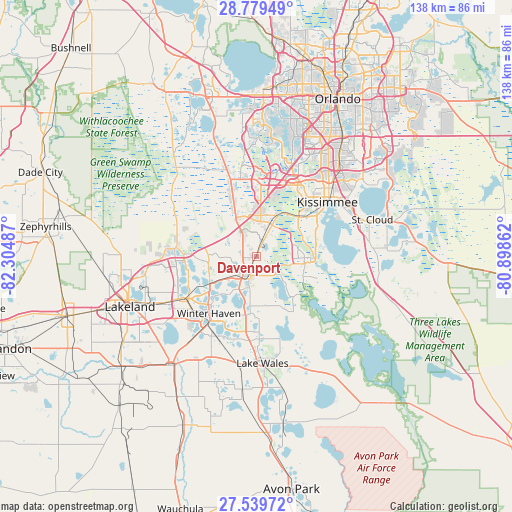
Davenport GPS coordinates[2]
28° 9' 41.04" North, 81° 36' 6.264" West
| Map corner | latitude | longitude |
|---|---|---|
| Upper-left | 28.77949°, | -82.30487° |
| Center: | 28.1614°, | -81.60174° |
| Lower-right: | 27.53972°, | -80.89862° |
| Map W x H: | 137.8×137.8 km | = 85.6×85.6mi |
| max Lat: | 71.29058° ⇑96.4% North |
| Davenport: | 28.1614° |
| min Lat: | ⇓3.6% South 19.06759° |
| min Long | Davenport | max Long |
| -171.73463° | -81.60174° | -66.98998° |
| W 67.1%⇐ | ⇒32.9% E |
Elevation
Elevation of Davenport is 47 m = 154 ft, and this is 247.8 m = 813 ft below average elevation for this country.
| Max E: |
3189 m = 10463 ft | 79.9% |
| Avg. | 294.8 m = 967 ft | |
| Davenport | 47 m = 154 ft | |
Min E: |
-60 m = -197 ft | 20.1% |
See also: United States elevation on elevation.city.
Geographical zone
Davenport is located in North temperate zone (between Tropic of Cancer and the Arctic Circle). Distance of this Northern Tropic circle is 525.3 km =326.4 mi to South.| Distance of | km | miles | from Davenport |
|---|---|---|---|
| North Pole | 6875.8 | 4272.4 | to North |
| Arctic Circle | 4269.9 | 2653.2 | to North |
| Tropic Cancer | 525.3 | 326.4 | to South |
| Equator | 3131.3 | 1945.7 | to South |


Nearby cities:
15 places around Davenport: (largest is in red/bold)
• Auburndale
21.2 km =13.2 mi,  239°
239°
• Campbell
17.9 km =11.1 mi,  52°
52°
• Celebration
19.4 km =12.1 mi,  20°
20°
• Citrus Ridge
19.6 km =12.2 mi,  348°
348°
• Cypress Gardens
20.5 km =12.7 mi,  204°
204°
• Dundee
15.5 km =9.6 mi,  186°
186°
• Four Corners
19.6 km =12.2 mi, 346°
• Haines City
5.5 km =3.4 mi, 199°
• Inwood
21.2 km =13.2 mi,  229°
229°
• Lake Alfred
14.2 km =8.8 mi, 237°
• Lake Hamilton
13.3 km =8.3 mi, 191°
• Loughman
9.6 km =6 mi, 20°
• Poinciana
14.2 km =8.8 mi,  99°
99°
• Waverly
20.3 km =12.6 mi,  183°
183°
• Winter Haven
20.1 km =12.5 mi,  219°
219°
Sources, notices
• [Note1] Compared only with cities in United States existing in our database
• [Src1] Map data: © OpenStreetMap contributors (CC-BY-SA)
• [Src2] Other city data from geonames.org with taken over terms of usage.
• [Src3] Geographical zone / Annual Mean Temperature by Robert A. Rohde @ Wikipedia
