Crystal River geodata
Crystal River (Florida) is a populated place; located in United States in America/New_York (GMT-4) time zone. With population of 3,089 people, there are 9482 cities with bigger population in this country. Compared to other cities in United States, 95.4% of cities are located further ↑North; 63.4% of cities are located further ←West and 95.7% of cities have higher elevation than Crystal River. Note1


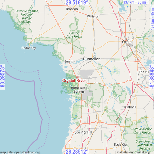
Crystal River GPS coordinates[2]
28° 54' 8.928" North, 82° 35' 33.36" West
| Map corner | latitude | longitude |
|---|---|---|
| Upper-left | 29.51619°, | -83.29573° |
| Center: | 28.90248°, | -82.5926° |
| Lower-right: | 28.28512°, | -81.88948° |
| Map W x H: | 136.9×136.9 km | = 85.1×85.1mi |
| max Lat: | 71.29058° ⇑95.4% North |
| Crystal River: | 28.90248° |
| min Lat: | ⇓4.6% South 19.06759° |
| min Long | Crystal River | max Long |
| -171.73463° | -82.5926° | -66.98998° |
| W 63.4%⇐ | ⇒36.6% E |
Elevation
Elevation of Crystal River is 8 m = 26 ft, and this is 286.8 m = 941 ft below average elevation for this country.
| Max E: |
3189 m = 10463 ft | 95.7% |
| Avg. | 294.8 m = 967 ft | |
| Crystal River | 8 m = 26 ft | |
Min E: |
-60 m = -197 ft | 4.3% |
See also: United States elevation on elevation.city.
Geographical zone
Crystal River is located in North temperate zone (between Tropic of Cancer and the Arctic Circle). Distance of this Northern Tropic circle is 607.7 km =377.6 mi to South.| Distance of | km | miles | from Crystal River |
|---|---|---|---|
| North Pole | 6793.4 | 4221.2 | to North |
| Arctic Circle | 4187.5 | 2602 | to North |
| Tropic Cancer | 607.7 | 377.6 | to South |
| Equator | 3213.7 | 1996.9 | to South |


Nearby cities:
15 places around Crystal River: (largest is in red/bold)
• Beverly Hills
13.2 km =8.2 mi,  83°
83°
• Black Diamond
10.4 km =6.5 mi, 83°
• Citrus Hills
15.7 km =9.8 mi,  95°
95°
• Citrus Springs
15.9 km =9.9 mi,  48°
48°
• Dunnellon
20.7 km =12.9 mi,  38°
38°
• Hernando
21.2 km =13.2 mi,  90°
90°
• Homosassa
13.6 km =8.5 mi,  189°
189°
• Homosassa Springs
11.1 km =6.9 mi,  171°
171°
• Inglis
16 km =9.9 mi,  332°
332°
• Inverness
26.6 km =16.5 mi,  106°
106°
• Inverness Highlands North
21.4 km =13.3 mi, 101°
• Lecanto
11.7 km =7.3 mi,  118°
118°
• Pine Ridge
12.3 km =7.6 mi,  71°
71°
• Sugarmill Woods
20.7 km =12.9 mi,  156°
156°
• Yankeetown
18.6 km =11.6 mi,  319°
319°
Sources, notices
• [Note1] Compared only with cities in United States existing in our database
• [Src1] Map data: © OpenStreetMap contributors (CC-BY-SA)
• [Src2] Other city data from geonames.org with taken over terms of usage.
• [Src3] Geographical zone / Annual Mean Temperature by Robert A. Rohde @ Wikipedia
