Sugarmill Woods geodata
Sugarmill Woods (Florida) is a populated place; located in United States in America/New_York (GMT-4) time zone. With population of 8,287 people, there are 5143 cities with bigger population in this country. Compared to other cities in United States, 95.6% of cities are located further ↑North; 63.8% of cities are located further ←West and 83.8% of cities have higher elevation than Sugarmill Woods. Note1


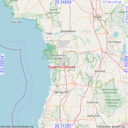
Sugarmill Woods GPS coordinates[2]
28° 43' 55.956" North, 82° 30' 22.356" West
| Map corner | latitude | longitude |
|---|---|---|
| Upper-left | 29.34694°, | -83.20934° |
| Center: | 28.73221°, | -82.50621° |
| Lower-right: | 28.11385°, | -81.80309° |
| Map W x H: | 137.1×137.1 km | = 85.2×85.2mi |
| max Lat: | 71.29058° ⇑95.6% North |
| Sugarmill Woods: | 28.73221° |
| min Lat: | ⇓4.4% South 19.06759° |
| min Long | Sugarmill Woods | max Long |
| -171.73463° | -82.50621° | -66.98998° |
| W 63.8%⇐ | ⇒36.2% E |
Elevation
Elevation of Sugarmill Woods is 32 m = 105 ft, and this is 262.8 m = 862 ft below average elevation for this country.
| Max E: |
3189 m = 10463 ft | 83.8% |
| Avg. | 294.8 m = 967 ft | |
| Sugarmill Woods | 32 m = 105 ft | |
Min E: |
-60 m = -197 ft | 16.2% |
See also: United States elevation on elevation.city.
Geographical zone
Sugarmill Woods is located in North temperate zone (between Tropic of Cancer and the Arctic Circle). Distance of this Northern Tropic circle is 588.8 km =365.9 mi to South.| Distance of | km | miles | from Sugarmill Woods |
|---|---|---|---|
| North Pole | 6812.3 | 4233 | to North |
| Arctic Circle | 4206.5 | 2613.8 | to North |
| Tropic Cancer | 588.8 | 365.9 | to South |
| Equator | 3194.7 | 1985.1 | to South |


Nearby cities:
15 places around Sugarmill Woods: (largest is in red/bold)
• Beverly Hills
21.1 km =13.1 mi,  12°
12°
• Black Diamond
20.1 km =12.5 mi, 5°
• Brookridge
20.2 km =12.6 mi,  176°
176°
• Citrus Hills
18.8 km =11.7 mi,  22°
22°
• Crystal River
20.7 km =12.9 mi,  336°
336°
• Floral City
20.5 km =12.7 mi,  84°
84°
• High Point
20.7 km =12.9 mi, 184°
• Homosassa
11.9 km =7.4 mi,  297°
297°
• Homosassa Springs
10.4 km =6.5 mi,  319°
319°
• Inverness
20.6 km =12.8 mi,  56°
56°
• Inverness Highlands North
19.3 km =12 mi,  40°
40°
• Inverness Highlands South
18.1 km =11.2 mi,  65°
65°
• Lecanto
13.4 km =8.3 mi, 7°
• North Brooksville
20.1 km =12.5 mi,  151°
151°
• North Weeki Wachee
20.9 km =13 mi,  194°
194°
Sources, notices
• [Note1] Compared only with cities in United States existing in our database
• [Src1] Map data: © OpenStreetMap contributors (CC-BY-SA)
• [Src2] Other city data from geonames.org with taken over terms of usage.
• [Src3] Geographical zone / Annual Mean Temperature by Robert A. Rohde @ Wikipedia
