Doral geodata
Doral (Florida) is a populated place; located in United States in America/New_York (GMT-4) time zone. With population of 56,035 people, there are 816 cities with bigger population in this country. Compared to other cities in United States, 99.1% of cities are located further ↑North; 71.4% of cities are located further ←West and 94.8% of cities have higher elevation than Doral. Note1


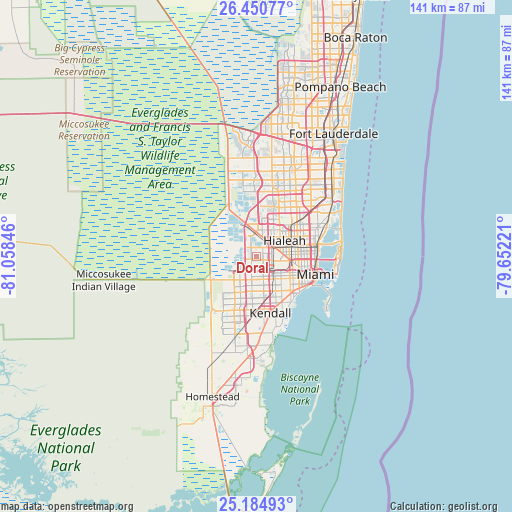
Doral GPS coordinates[2]
25° 49' 10.344" North, 80° 21' 19.188" West
| Map corner | latitude | longitude |
|---|---|---|
| Upper-left | 26.45077°, | -81.05846° |
| Center: | 25.81954°, | -80.35533° |
| Lower-right: | 25.18493°, | -79.65221° |
| Map W x H: | 140.7×140.8 km | = 87.4×87.5mi |
| max Lat: | 71.29058° ⇑99.1% North |
| Doral: | 25.81954° |
| min Lat: | ⇓0.9% South 19.06759° |
| min Long | Doral | max Long |
| -171.73463° | -80.35533° | -66.98998° |
| W 71.4%⇐ | ⇒28.6% E |
Elevation
Elevation of Doral is 9 m = 30 ft, and this is 285.8 m = 938 ft below average elevation for this country.
| Max E: |
3189 m = 10463 ft | 94.8% |
| Avg. | 294.8 m = 967 ft | |
| Doral | 9 m = 30 ft | |
Min E: |
-60 m = -197 ft | 5.2% |
See also: Doral elevation on elevation.city.
Geographical zone
Doral is located in North temperate zone (between Tropic of Cancer and the Arctic Circle). Distance of this Northern Tropic circle is 264.9 km =164.6 mi to South.| Distance of | km | miles | from Doral |
|---|---|---|---|
| North Pole | 7136.2 | 4434.2 | to North |
| Arctic Circle | 4530.3 | 2815 | to North |
| Tropic Cancer | 264.9 | 164.6 | to South |
| Equator | 2870.9 | 1783.9 | to South |


Nearby cities:
15 places around Doral: (largest is in red/bold)
• Coral Terrace
9.6 km =6 mi,  148°
148°
• Flagami
7.5 km =4.7 mi, 148°
• Fountainebleau
5.2 km =3.2 mi,  171°
171°
• Hialeah
8.8 km =5.5 mi,  61°
61°
• Hialeah Gardens
5.9 km =3.7 mi,  31°
31°
• Medley
3.7 km =2.3 mi,  50°
50°
• Miami Springs
6.6 km =4.1 mi,  87°
87°
• Olympia Heights
10.3 km =6.4 mi,  180°
180°
• Sweetwater
6.5 km =4 mi,  195°
195°
• Tamiami
8 km =5 mi,  212°
212°
• University Park
8.2 km =5.1 mi,  188°
188°
• Virginia Gardens
5.4 km =3.4 mi,  100°
100°
• West Miami
8.6 km =5.3 mi,  136°
136°
• Westchester
7.7 km =4.8 mi,  158°
158°
• Westwood Lake
10.2 km =6.3 mi, 189°
Sources, notices
• [Note1] Compared only with cities in United States existing in our database
• [Src1] Map data: © OpenStreetMap contributors (CC-BY-SA)
• [Src2] Other city data from geonames.org with taken over terms of usage.
• [Src3] Geographical zone / Annual Mean Temperature by Robert A. Rohde @ Wikipedia
