Fountainebleau geodata
Fountainebleau (Florida) is a populated place; located in United States in America/New_York (GMT-4) time zone. With population of 59,764 people, there are 753 cities with bigger population in this country. Compared to other cities in United States, 99.1% of cities are located further ↑North; 71.4% of cities are located further ←West and 95.7% of cities have higher elevation than Fountainebleau. Note1


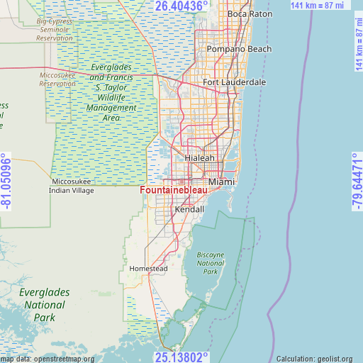
Fountainebleau GPS coordinates[2]
25° 46' 22.368" North, 80° 20' 52.188" West
| Map corner | latitude | longitude |
|---|---|---|
| Upper-left | 26.40436°, | -81.05096° |
| Center: | 25.77288°, | -80.34783° |
| Lower-right: | 25.13802°, | -79.64471° |
| Map W x H: | 140.8×140.8 km | = 87.5×87.5mi |
| max Lat: | 71.29058° ⇑99.1% North |
| Fountainebleau: | 25.77288° |
| min Lat: | ⇓0.9% South 19.06759° |
| min Long | Fountainebleau | max Long |
| -171.73463° | -80.34783° | -66.98998° |
| W 71.4%⇐ | ⇒28.6% E |
Elevation
Elevation of Fountainebleau is 8 m = 26 ft, and this is 286.8 m = 941 ft below average elevation for this country.
| Max E: |
3189 m = 10463 ft | 95.7% |
| Avg. | 294.8 m = 967 ft | |
| Fountainebleau | 8 m = 26 ft | |
Min E: |
-60 m = -197 ft | 4.3% |
See also: Fountainebleau elevation on elevation.city.
Geographical zone
Fountainebleau is located in North temperate zone (between Tropic of Cancer and the Arctic Circle). Distance of this Northern Tropic circle is 259.8 km =161.4 mi to South.| Distance of | km | miles | from Fountainebleau |
|---|---|---|---|
| North Pole | 7141.4 | 4437.5 | to North |
| Arctic Circle | 4535.5 | 2818.2 | to North |
| Tropic Cancer | 259.8 | 161.4 | to South |
| Equator | 2865.7 | 1780.7 | to South |


Nearby cities:
15 places around Fountainebleau: (largest is in red/bold)
• Coral Terrace
5.3 km =3.3 mi,  124°
124°
• Doral
5.2 km =3.2 mi,  351°
351°
• Flagami
3.4 km =2.1 mi,  110°
110°
• Glenvar Heights
7.6 km =4.7 mi,  162°
162°
• Medley
7.8 km =4.8 mi,  15°
15°
• Miami Springs
8 km =5 mi,  46°
46°
• Olympia Heights
5.2 km =3.2 mi,  188°
188°
• Sunset
7.5 km =4.7 mi,  183°
183°
• Sweetwater
2.7 km =1.7 mi,  247°
247°
• Tamiami
5.3 km =3.3 mi, 252°
• University Park
3.5 km =2.2 mi,  213°
213°
• Virginia Gardens
6.2 km =3.9 mi, 47°
• West Miami
5.3 km =3.3 mi,  101°
101°
• Westchester
2.9 km =1.8 mi,  134°
134°
• Westwood Lake
5.5 km =3.4 mi, 207°
Sources, notices
• [Note1] Compared only with cities in United States existing in our database
• [Src1] Map data: © OpenStreetMap contributors (CC-BY-SA)
• [Src2] Other city data from geonames.org with taken over terms of usage.
• [Src3] Geographical zone / Annual Mean Temperature by Robert A. Rohde @ Wikipedia
