Harold geodata
Harold (Florida) is a populated place; located in United States in America/Chicago (GMT-5) time zone. With population of 823 people, there are 17588 cities with bigger population in this country. Compared to other cities in United States, 91.4% of cities are located further ↑North; 50.6% of cities are located further ←West and 78.8% of cities have higher elevation than Harold. Note1


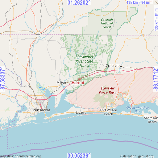
Harold GPS coordinates[2]
30° 39' 32.688" North, 86° 52' 48.864" West
| Map corner | latitude | longitude |
|---|---|---|
| Upper-left | 31.26202°, | -87.58337° |
| Center: | 30.65908°, | -86.88024° |
| Lower-right: | 30.05236°, | -86.17712° |
| Map W x H: | 134.5×134.5 km | = 83.6×83.6mi |
| max Lat: | 71.29058° ⇑91.4% North |
| Harold: | 30.65908° |
| min Lat: | ⇓8.6% South 19.06759° |
| min Long | Harold | max Long |
| -171.73463° | -86.88024° | -66.98998° |
| W 50.6%⇐ | ⇒49.4% E |
Elevation
Elevation of Harold is 52 m = 171 ft, and this is 242.8 m = 797 ft below average elevation for this country.
| Max E: |
3189 m = 10463 ft | 78.8% |
| Avg. | 294.8 m = 967 ft | |
| Harold | 52 m = 171 ft | |
Min E: |
-60 m = -197 ft | 21.2% |
See also: United States elevation on elevation.city.
Geographical zone
Harold is located in North temperate zone (between Tropic of Cancer and the Arctic Circle). Distance of this Northern Tropic circle is 803.1 km =499 mi to South.| Distance of | km | miles | from Harold |
|---|---|---|---|
| North Pole | 6598.1 | 4099.9 | to North |
| Arctic Circle | 3992.2 | 2480.6 | to North |
| Tropic Cancer | 803.1 | 499 | to South |
| Equator | 3409 | 2118.3 | to South |


Nearby cities:
15 places around Harold: (largest is in red/bold)
• Allentown
19.3 km =12 mi,  306°
306°
• Bagdad
16 km =9.9 mi,  245°
245°
• Crestview
31.7 km =19.7 mi,  68°
68°
• East Milton
14.4 km =8.9 mi, 250°
• Holley
23.7 km =14.7 mi,  186°
186°
• Mary Esther
34.5 km =21.4 mi,  143°
143°
• Midway
30.5 km =19 mi,  203°
203°
• Milton
15.5 km =9.6 mi,  258°
258°
• Navarre
28.7 km =17.8 mi,  176°
176°
• Pace
27.7 km =17.2 mi, 256°
• Point Baker
16.9 km =10.5 mi,  281°
281°
• Roeville
11 km =6.8 mi, 280°
• Wallace
28.7 km =17.8 mi,  274°
274°
• Woodlawn Beach
31.9 km =19.8 mi, 199°
• Wright
32.4 km =20.1 mi,  134°
134°
Sources, notices
• [Note1] Compared only with cities in United States existing in our database
• [Src1] Map data: © OpenStreetMap contributors (CC-BY-SA)
• [Src2] Other city data from geonames.org with taken over terms of usage.
• [Src3] Geographical zone / Annual Mean Temperature by Robert A. Rohde @ Wikipedia
