Fruitland Park geodata
Fruitland Park (Florida) is a populated place; located in United States in America/New_York (GMT-4) time zone. With population of 4,483 people, there are 7662 cities with bigger population in this country. Compared to other cities in United States, 95.4% of cities are located further ↑North; 65.9% of cities are located further ←West and 82.1% of cities have higher elevation than Fruitland Park. Note1


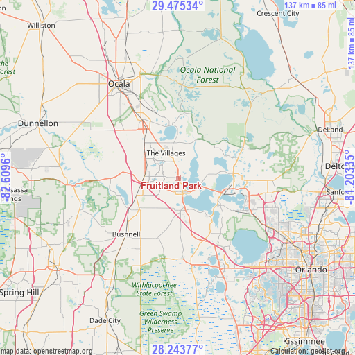
Fruitland Park GPS coordinates[2]
28° 51' 40.968" North, 81° 54' 23.292" West
| Map corner | latitude | longitude |
|---|---|---|
| Upper-left | 29.47534°, | -82.6096° |
| Center: | 28.86138°, | -81.90647° |
| Lower-right: | 28.24377°, | -81.20335° |
| Map W x H: | 136.9×136.9 km | = 85.1×85.1mi |
| max Lat: | 71.29058° ⇑95.4% North |
| Fruitland Park: | 28.86138° |
| min Lat: | ⇓4.6% South 19.06759° |
| min Long | Fruitland Park | max Long |
| -171.73463° | -81.90647° | -66.98998° |
| W 65.9%⇐ | ⇒34.1% E |
Elevation
Elevation of Fruitland Park is 38 m = 125 ft, and this is 256.8 m = 843 ft below average elevation for this country.
| Max E: |
3189 m = 10463 ft | 82.1% |
| Avg. | 294.8 m = 967 ft | |
| Fruitland Park | 38 m = 125 ft | |
Min E: |
-60 m = -197 ft | 17.9% |
See also: United States elevation on elevation.city.
Geographical zone
Fruitland Park is located in North temperate zone (between Tropic of Cancer and the Arctic Circle). Distance of this Northern Tropic circle is 603.2 km =374.8 mi to South.| Distance of | km | miles | from Fruitland Park |
|---|---|---|---|
| North Pole | 6798 | 4224.1 | to North |
| Arctic Circle | 4192.1 | 2604.8 | to North |
| Tropic Cancer | 603.2 | 374.8 | to South |
| Equator | 3209.1 | 1994 | to South |


Nearby cities:
15 places around Fruitland Park: (largest is in red/bold)
• Astatula
23.9 km =14.9 mi,  134°
134°
• Center Hill
25 km =15.5 mi,  199°
199°
• Coleman
17.4 km =10.8 mi,  246°
246°
• Eustis
21.6 km =13.4 mi,  92°
92°
• Hawthorne
11.6 km =7.2 mi,  162°
162°
• Howey-in-the-Hills
20.6 km =12.8 mi,  141°
141°
• Lady Lake
6.4 km =4 mi,  345°
345°
• Lake Panasoffkee
21.8 km =13.5 mi,  237°
237°
• Leesburg
6.3 km =3.9 mi,  153°
153°
• Silver Lake
10.7 km =6.6 mi,  101°
101°
• Tavares
18.7 km =11.6 mi,  109°
109°
• The Villages
9.6 km =6 mi,  327°
327°
• Umatilla
24.6 km =15.3 mi,  72°
72°
• Wildwood
13.1 km =8.1 mi,  271°
271°
• Yalaha
16.6 km =10.3 mi, 145°
Sources, notices
• [Note1] Compared only with cities in United States existing in our database
• [Src1] Map data: © OpenStreetMap contributors (CC-BY-SA)
• [Src2] Other city data from geonames.org with taken over terms of usage.
• [Src3] Geographical zone / Annual Mean Temperature by Robert A. Rohde @ Wikipedia
