Indian River Estates geodata
Indian River Estates (Florida) is a populated place; located in United States in America/New_York (GMT-4) time zone. With population of 6,220 people, there are 6262 cities with bigger population in this country. Compared to other cities in United States, 97.3% of cities are located further ↑North; 71.7% of cities are located further ←West and 93.9% of cities have higher elevation than Indian River Estates. Note1


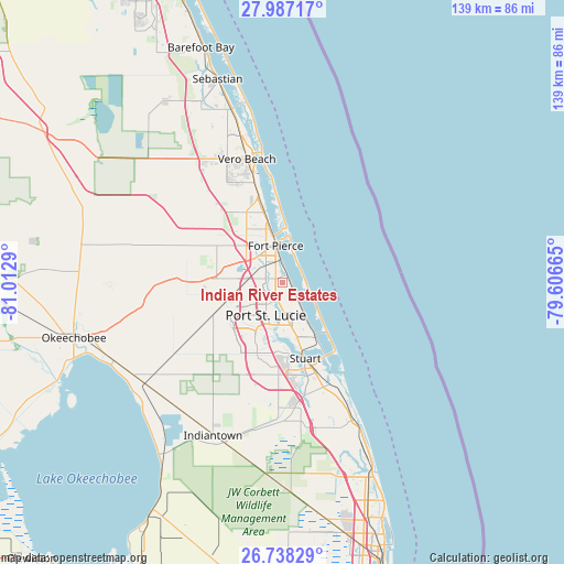
Indian River Estates GPS coordinates[2]
27° 21' 52.164" North, 80° 18' 35.172" West
| Map corner | latitude | longitude |
|---|---|---|
| Upper-left | 27.98717°, | -81.0129° |
| Center: | 27.36449°, | -80.30977° |
| Lower-right: | 26.73829°, | -79.60665° |
| Map W x H: | 138.9×138.9 km | = 86.3×86.3mi |
| max Lat: | 71.29058° ⇑97.3% North |
| Indian River Estates: | 27.36449° |
| min Lat: | ⇓2.7% South 19.06759° |
| min Long | Indian River Es | max Long |
| -171.73463° | -80.30977° | -66.98998° |
| W 71.7%⇐ | ⇒28.3% E |
Elevation
Elevation of Indian River Estates is 10 m = 33 ft, and this is 284.8 m = 934 ft below average elevation for this country.
| Max E: |
3189 m = 10463 ft | 93.9% |
| Avg. | 294.8 m = 967 ft | |
| Indian River Estates | 10 m = 33 ft | |
Min E: |
-60 m = -197 ft | 6.1% |
See also: United States elevation on elevation.city.
Geographical zone
Indian River Estates is located in North temperate zone (between Tropic of Cancer and the Arctic Circle). Distance of this Northern Tropic circle is 436.7 km =271.4 mi to South.| Distance of | km | miles | from Indian River Estates |
|---|---|---|---|
| North Pole | 6964.4 | 4327.5 | to North |
| Arctic Circle | 4358.5 | 2708.2 | to North |
| Tropic Cancer | 436.7 | 271.4 | to South |
| Equator | 3042.6 | 1890.6 | to South |


Nearby cities:
15 places around Indian River Estates: (largest is in red/bold)
• Fort Pierce
9.3 km =5.8 mi,  350°
350°
• Fort Pierce North
13.1 km =8.1 mi,  338°
338°
• Fort Pierce South
6.7 km =4.2 mi,  318°
318°
• Hutchinson Island South
11.4 km =7.1 mi,  129°
129°
• Jensen Beach
14.6 km =9.1 mi,  147°
147°
• Lakewood Park
14.5 km =9 mi,  333°
333°
• Lakewood Park
21.9 km =13.6 mi, 335°
• North River Shores
16.8 km =10.4 mi,  166°
166°
• Port Saint Lucie
8.8 km =5.5 mi,  207°
207°
• Rio
17.6 km =10.9 mi,  156°
156°
• River Park
6.7 km =4.2 mi, 213°
• Saint Lucie
14.2 km =8.8 mi, 347°
• Sewall's Point
21.2 km =13.2 mi, 149°
• Stuart
19.4 km =12.1 mi, 163°
• White City
2.6 km =1.6 mi,  293°
293°
Sources, notices
• [Note1] Compared only with cities in United States existing in our database
• [Src1] Map data: © OpenStreetMap contributors (CC-BY-SA)
• [Src2] Other city data from geonames.org with taken over terms of usage.
• [Src3] Geographical zone / Annual Mean Temperature by Robert A. Rohde @ Wikipedia
