Lakewood Park geodata
Lakewood Park (Florida) is a populated place; located in United States in America/New_York (GMT-4) time zone. With population of 11,323 people, there are 4077 cities with bigger population in this country. Compared to other cities in United States, 97.2% of cities are located further ↑North; 71.2% of cities are located further ←West and 91.5% of cities have higher elevation than Lakewood Park. Note1


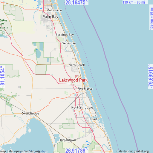
Lakewood Park GPS coordinates[2]
27° 32' 35.124" North, 80° 24' 8.172" West
| Map corner | latitude | longitude |
|---|---|---|
| Upper-left | 28.16475°, | -81.1054° |
| Center: | 27.54309°, | -80.40227° |
| Lower-right: | 26.91789°, | -79.69915° |
| Map W x H: | 138.6×138.6 km | = 86.1×86.1mi |
| max Lat: | 71.29058° ⇑97.2% North |
| Lakewood Park: | 27.54309° |
| min Lat: | ⇓2.8% South 19.06759° |
| min Long | Lakewood Park | max Long |
| -171.73463° | -80.40227° | -66.98998° |
| W 71.2%⇐ | ⇒28.8% E |
Elevation
Elevation of Lakewood Park is 13 m = 43 ft, and this is 281.8 m = 925 ft below average elevation for this country.
| Max E: |
3189 m = 10463 ft | 91.5% |
| Avg. | 294.8 m = 967 ft | |
| Lakewood Park | 13 m = 43 ft | |
Min E: |
-60 m = -197 ft | 8.5% |
See also: United States elevation on elevation.city.
Geographical zone
Lakewood Park is located in North temperate zone (between Tropic of Cancer and the Arctic Circle). Distance of this Northern Tropic circle is 456.6 km =283.7 mi to South.| Distance of | km | miles | from Lakewood Park |
|---|---|---|---|
| North Pole | 6944.6 | 4315.2 | to North |
| Arctic Circle | 4338.7 | 2695.9 | to North |
| Tropic Cancer | 456.6 | 283.7 | to South |
| Equator | 3062.5 | 1902.9 | to South |


Nearby cities:
15 places around Lakewood Park: (largest is in red/bold)
• Florida Ridge
4.4 km =2.7 mi,  20°
20°
• Fort Pierce
13.1 km =8.1 mi,  144°
144°
• Fort Pierce North
8.8 km =5.5 mi,  151°
151°
• Fort Pierce South
15.6 km =9.7 mi,  162°
162°
• Gifford
14.7 km =9.1 mi,  357°
357°
• Indian River Estates
21.9 km =13.6 mi, 155°
• Indian River Shores
19.4 km =12.1 mi,  5°
5°
• Lakewood Park
7.4 km =4.6 mi, 158°
• Saint Lucie
8.6 km =5.3 mi,  134°
134°
• South Beach
7.8 km =4.8 mi,  46°
46°
• Vero Beach
10.6 km =6.6 mi,  2°
2°
• Vero Beach South
8.2 km =5.1 mi,  352°
352°
• West Vero Corridor
13.4 km =8.3 mi,  321°
321°
• White City
20 km =12.4 mi, 160°
• Winter Beach
19.7 km =12.2 mi, 354°
Sources, notices
• [Note1] Compared only with cities in United States existing in our database
• [Src1] Map data: © OpenStreetMap contributors (CC-BY-SA)
• [Src2] Other city data from geonames.org with taken over terms of usage.
• [Src3] Geographical zone / Annual Mean Temperature by Robert A. Rohde @ Wikipedia
