Kendall geodata
Kendall (Florida) is a populated place; located in United States in America/New_York (GMT-4) time zone. With population of 75,371 people, there are 536 cities with bigger population in this country. Compared to other cities in United States, 99.2% of cities are located further ↑North; 71.6% of cities are located further ←West and 92.1% of cities have higher elevation than Kendall. Note1


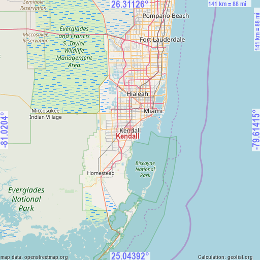
Kendall GPS coordinates[2]
25° 40' 45.372" North, 80° 19' 2.172" West
| Map corner | latitude | longitude |
|---|---|---|
| Upper-left | 26.31126°, | -81.0204° |
| Center: | 25.67927°, | -80.31727° |
| Lower-right: | 25.04392°, | -79.61415° |
| Map W x H: | 140.9×140.9 km | = 87.6×87.6mi |
| max Lat: | 71.29058° ⇑99.2% North |
| Kendall: | 25.67927° |
| min Lat: | ⇓0.8% South 19.06759° |
| min Long | Kendall | max Long |
| -171.73463° | -80.31727° | -66.98998° |
| W 71.6%⇐ | ⇒28.4% E |
Elevation
Elevation of Kendall is 12 m = 39 ft, and this is 282.8 m = 928 ft below average elevation for this country.
| Max E: |
3189 m = 10463 ft | 92.1% |
| Avg. | 294.8 m = 967 ft | |
| Kendall | 12 m = 39 ft | |
Min E: |
-60 m = -197 ft | 7.9% |
See also: Kendall elevation on elevation.city.
Geographical zone
Kendall is located in North temperate zone (between Tropic of Cancer and the Arctic Circle). Distance of this Northern Tropic circle is 249.3 km =154.9 mi to South.| Distance of | km | miles | from Kendall |
|---|---|---|---|
| North Pole | 7151.8 | 4443.9 | to North |
| Arctic Circle | 4545.9 | 2824.7 | to North |
| Tropic Cancer | 249.3 | 154.9 | to South |
| Equator | 2855.3 | 1774.2 | to South |


Nearby cities:
15 places around Kendall: (largest is in red/bold)
• Coconut Grove
7.1 km =4.4 mi,  58°
58°
• Coral Gables
6.8 km =4.2 mi,  46°
46°
• Coral Terrace
7.5 km =4.7 mi,  9°
9°
• Cutler
7.2 km =4.5 mi,  174°
174°
• East Perrine
8.1 km =5 mi,  195°
195°
• Glenvar Heights
3.3 km =2.1 mi,  345°
345°
• Olympia Heights
6.5 km =4 mi,  324°
324°
• Palmetto Bay
6.4 km =4 mi,  186°
186°
• Palmetto Estates
7.8 km =4.8 mi,  214°
214°
• Pinecrest
1.6 km =1 mi,  145°
145°
• Richmond Heights
7.4 km =4.6 mi,  224°
224°
• South Miami
4 km =2.5 mi,  37°
37°
• Sunset
4.6 km =2.9 mi,  310°
310°
• The Crossings
8.5 km =5.3 mi,  263°
263°
• Westwood Lake
7.9 km =4.9 mi, 314°
Sources, notices
• [Note1] Compared only with cities in United States existing in our database
• [Src1] Map data: © OpenStreetMap contributors (CC-BY-SA)
• [Src2] Other city data from geonames.org with taken over terms of usage.
• [Src3] Geographical zone / Annual Mean Temperature by Robert A. Rohde @ Wikipedia
