Glenvar Heights geodata
Glenvar Heights (Florida) is a populated place; located in United States in America/New_York (GMT-4) time zone. With population of 16,898 people, there are 2911 cities with bigger population in this country. Compared to other cities in United States, 99.2% of cities are located further ↑North; 71.6% of cities are located further ←West and 93% of cities have higher elevation than Glenvar Heights. Note1


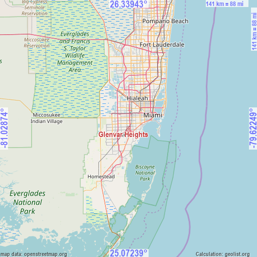
Glenvar Heights GPS coordinates[2]
25° 42' 27.36" North, 80° 19' 32.196" West
| Map corner | latitude | longitude |
|---|---|---|
| Upper-left | 26.33943°, | -81.02874° |
| Center: | 25.7076°, | -80.32561° |
| Lower-right: | 25.07239°, | -79.62249° |
| Map W x H: | 140.9×140.9 km | = 87.6×87.6mi |
| max Lat: | 71.29058° ⇑99.2% North |
| Glenvar Heights: | 25.7076° |
| min Lat: | ⇓0.8% South 19.06759° |
| min Long | Glenvar Heights | max Long |
| -171.73463° | -80.32561° | -66.98998° |
| W 71.6%⇐ | ⇒28.4% E |
Elevation
Elevation of Glenvar Heights is 11 m = 36 ft, and this is 283.8 m = 931 ft below average elevation for this country.
| Max E: |
3189 m = 10463 ft | 93% |
| Avg. | 294.8 m = 967 ft | |
| Glenvar Heights | 11 m = 36 ft | |
Min E: |
-60 m = -197 ft | 7% |
See also: United States elevation on elevation.city.
Geographical zone
Glenvar Heights is located in North temperate zone (between Tropic of Cancer and the Arctic Circle). Distance of this Northern Tropic circle is 252.5 km =156.9 mi to South.| Distance of | km | miles | from Glenvar Heights |
|---|---|---|---|
| North Pole | 7148.6 | 4441.9 | to North |
| Arctic Circle | 4542.8 | 2822.8 | to North |
| Tropic Cancer | 252.5 | 156.9 | to South |
| Equator | 2858.4 | 1776.1 | to South |


Nearby cities:
15 places around Glenvar Heights: (largest is in red/bold)
• Coconut Grove
6.9 km =4.3 mi,  85°
85°
• Coral Gables
5.9 km =3.7 mi,  74°
74°
• Coral Terrace
4.8 km =3 mi,  26°
26°
• Flagami
6.2 km =3.9 mi,  8°
8°
• Fountainebleau
7.6 km =4.7 mi,  342°
342°
• Kendall
3.3 km =2.1 mi,  165°
165°
• Olympia Heights
3.7 km =2.3 mi,  305°
305°
• Pinecrest
4.8 km =3 mi,  158°
158°
• South Miami
3.2 km =2 mi, 90°
• Sunset
2.7 km =1.7 mi,  266°
266°
• Sweetwater
7.8 km =4.8 mi,  322°
322°
• University Park
6 km =3.7 mi, 315°
• West Miami
6.9 km =4.3 mi, 25°
• Westchester
5.3 km =3.3 mi,  358°
358°
• Westwood Lake
5.3 km =3.3 mi,  296°
296°
Sources, notices
• [Note1] Compared only with cities in United States existing in our database
• [Src1] Map data: © OpenStreetMap contributors (CC-BY-SA)
• [Src2] Other city data from geonames.org with taken over terms of usage.
• [Src3] Geographical zone / Annual Mean Temperature by Robert A. Rohde @ Wikipedia
