Lauderdale-by-the-Sea geodata
Lauderdale-by-the-Sea (Florida) is a populated place; located in United States in America/New_York (GMT-4) time zone. With population of 6,460 people, there are 6135 cities with bigger population in this country. Compared to other cities in United States, 98.5% of cities are located further ↑North; 72.8% of cities are located further ←West and 94.8% of cities have higher elevation than Lauderdale-by-the-Sea. Note1
Current local time in Lauderdale-by-the-Sea:
12:48 AM, WednesdayDifference from your time zone: hours


Lauderdale-by-the-Sea GPS coordinates[2]
26° 11' 31.308" North, 80° 5' 47.148" West
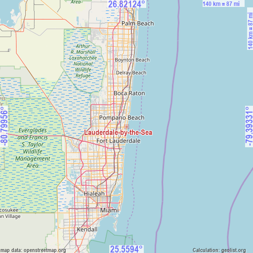
| Map corner | latitude | longitude |
|---|---|---|
| Upper-left | 26.82124°, | -80.79956° |
| Center: | 26.19203°, | -80.09643° |
| Lower-right: | 25.5594°, | -79.39331° |
| Map W x H: | 140.3×140.3 km | = 87.2×87.2mi |
| max Lat: | 71.29058° ⇑98.5% North |
| Lauderdale-by-the-Sea: | 26.19203° |
| min Lat: | ⇓1.5% South 19.06759° |
| min Long | Lauderdale-by-t | max Long |
| -171.73463° | -80.09643° | -66.98998° |
| W 72.8%⇐ | ⇒27.2% E |
Elevation
Elevation of Lauderdale-by-the-Sea is 9 m = 30 ft, and this is 285.8 m = 938 ft below average elevation for this country.
| Max E: |
3189 m = 10463 ft | 94.8% |
| Avg. | 294.8 m = 967 ft | |
| Lauderdale-by-the-Sea | 9 m = 30 ft | |
Min E: |
-60 m = -197 ft | 5.2% |
See also: United States elevation on elevation.city.
Geographical zone
Lauderdale-by-the-Sea is located in North temperate zone (between Tropic of Cancer and the Arctic Circle). Distance of this Northern Tropic circle is 306.4 km =190.4 mi to South.| Distance of | km | miles | from Lauderdale-by-the-Sea |
|---|---|---|---|
| North Pole | 7094.8 | 4408.5 | to North |
| Arctic Circle | 4488.9 | 2789.3 | to North |
| Tropic Cancer | 306.4 | 190.4 | to South |
| Equator | 2912.3 | 1809.6 | to South |


Nearby cities:
15 places around Lauderdale-by-the-Sea: (largest is in red/bold)
• Fort Lauderdale
9.1 km =5.7 mi,  211°
211°
• Franklin Park
10.2 km =6.3 mi,  231°
231°
• Kendall Green
7.4 km =4.6 mi,  338°
338°
• Lighthouse Point
9.3 km =5.8 mi,  5°
5°
• North Andrews Gardens
4.8 km =3 mi,  269°
269°
• Oakland Park
4.2 km =2.6 mi,  238°
238°
• Palm Aire
9.6 km =6 mi,  279°
279°
• Pompano Beach
5.8 km =3.6 mi,  330°
330°
• Rock Island
9 km =5.6 mi, 242°
• Roosevelt Gardens
10.1 km =6.3 mi, 235°
• Sea Ranch Lakes
1.2 km =0.7 mi, 12°
• Sunrise
6.7 km =4.2 mi,  194°
194°
• Terra Mar
2.7 km =1.7 mi,  2°
2°
• Twin Lakes
6.5 km =4 mi,  258°
258°
• Wilton Manors
5.5 km =3.4 mi, 230°
Sources, notices
• [Note1] Compared only with cities in United States existing in our database
• [Src1] Map data: © OpenStreetMap contributors (CC-BY-SA)
• [Src2] Other city data from geonames.org with taken over terms of usage.
• [Src3] Geographical zone / Annual Mean Temperature by Robert A. Rohde @ Wikipedia
