Sunrise geodata
Sunrise (Florida) is a populated place; located in United States in America/New_York (GMT-4) time zone. With population of 84,439 people, there are 460 cities with bigger population in this country. Compared to other cities in United States, 98.6% of cities are located further ↑North; 72.7% of cities are located further ←West and 95.7% of cities have higher elevation than Sunrise. Note1


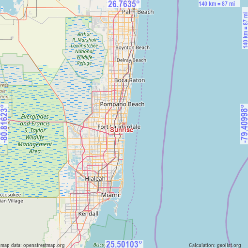
Sunrise GPS coordinates[2]
26° 8' 2.292" North, 80° 6' 47.16" West
| Map corner | latitude | longitude |
|---|---|---|
| Upper-left | 26.7635°, | -80.81623° |
| Center: | 26.13397°, | -80.1131° |
| Lower-right: | 25.50103°, | -79.40998° |
| Map W x H: | 140.4×140.4 km | = 87.2×87.2mi |
| max Lat: | 71.29058° ⇑98.6% North |
| Sunrise: | 26.13397° |
| min Lat: | ⇓1.4% South 19.06759° |
| min Long | Sunrise | max Long |
| -171.73463° | -80.1131° | -66.98998° |
| W 72.7%⇐ | ⇒27.3% E |
Elevation
Elevation of Sunrise is 8 m = 26 ft, and this is 286.8 m = 941 ft below average elevation for this country.
| Max E: |
3189 m = 10463 ft | 95.7% |
| Avg. | 294.8 m = 967 ft | |
| Sunrise | 8 m = 26 ft | |
Min E: |
-60 m = -197 ft | 4.3% |
See also: Sunrise elevation on elevation.city.
Geographical zone
Sunrise is located in North temperate zone (between Tropic of Cancer and the Arctic Circle). Distance of this Northern Tropic circle is 299.9 km =186.3 mi to South.| Distance of | km | miles | from Sunrise |
|---|---|---|---|
| North Pole | 7101.2 | 4412.5 | to North |
| Arctic Circle | 4495.3 | 2793.2 | to North |
| Tropic Cancer | 299.9 | 186.3 | to South |
| Equator | 2905.8 | 1805.6 | to South |


Nearby cities:
15 places around Sunrise: (largest is in red/bold)
• Boulevard Gardens
6.8 km =4.2 mi,  259°
259°
• Broward Estates
8.1 km =5 mi, 263°
• Fort Lauderdale
3.3 km =2.1 mi,  246°
246°
• Franklin Park
6.3 km =3.9 mi,  270°
270°
• Lauderdale-by-the-Sea
6.7 km =4.2 mi,  14°
14°
• Melrose Park
8.3 km =5.2 mi, 254°
• North Andrews Gardens
7.1 km =4.4 mi,  334°
334°
• Oakland Park
4.7 km =2.9 mi,  336°
336°
• Rock Island
6.8 km =4.2 mi,  290°
290°
• Roosevelt Gardens
6.7 km =4.2 mi,  276°
276°
• Sea Ranch Lakes
7.9 km =4.9 mi, 14°
• Terra Mar
9.3 km =5.8 mi, 10°
• Twin Lakes
7 km =4.3 mi,  318°
318°
• Washington Park
6.8 km =4.2 mi, 268°
• Wilton Manors
3.9 km =2.4 mi, 318°
Sources, notices
• [Note1] Compared only with cities in United States existing in our database
• [Src1] Map data: © OpenStreetMap contributors (CC-BY-SA)
• [Src2] Other city data from geonames.org with taken over terms of usage.
• [Src3] Geographical zone / Annual Mean Temperature by Robert A. Rohde @ Wikipedia
