Loxahatchee Groves geodata
Loxahatchee Groves (Florida) is a populated place; located in United States in America/New_York (GMT-4) time zone. With population of 3,397 people, there are 8999 cities with bigger population in this country. Compared to other cities in United States, 97.8% of cities are located further ↑North; 71.8% of cities are located further ←West and 90% of cities have higher elevation than Loxahatchee Groves. Note1


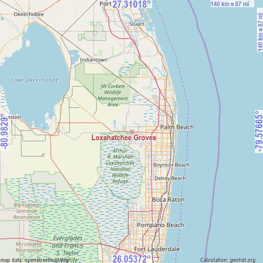
Loxahatchee Groves GPS coordinates[2]
26° 41' 1.248" North, 80° 16' 47.172" West
| Map corner | latitude | longitude |
|---|---|---|
| Upper-left | 27.31018°, | -80.9829° |
| Center: | 26.68368°, | -80.27977° |
| Lower-right: | 26.05372°, | -79.57665° |
| Map W x H: | 139.7×139.7 km | = 86.8×86.8mi |
| max Lat: | 71.29058° ⇑97.8% North |
| Loxahatchee Groves: | 26.68368° |
| min Lat: | ⇓2.2% South 19.06759° |
| min Long | Loxahatchee Gro | max Long |
| -171.73463° | -80.27977° | -66.98998° |
| W 71.8%⇐ | ⇒28.2% E |
Elevation
Elevation of Loxahatchee Groves is 16 m = 52 ft, and this is 278.8 m = 915 ft below average elevation for this country.
| Max E: |
3189 m = 10463 ft | 90% |
| Avg. | 294.8 m = 967 ft | |
| Loxahatchee Groves | 16 m = 52 ft | |
Min E: |
-60 m = -197 ft | 10% |
See also: United States elevation on elevation.city.
Geographical zone
Loxahatchee Groves is located in North temperate zone (between Tropic of Cancer and the Arctic Circle). Distance of this Northern Tropic circle is 361 km =224.3 mi to South.| Distance of | km | miles | from Loxahatchee Groves |
|---|---|---|---|
| North Pole | 7040.1 | 4374.5 | to North |
| Arctic Circle | 4434.2 | 2755.3 | to North |
| Tropic Cancer | 361 | 224.3 | to South |
| Equator | 2966.9 | 1843.5 | to South |


Nearby cities:
15 places around Loxahatchee Groves: (largest is in red/bold)
• Aberdeen
19.7 km =12.2 mi,  138°
138°
• Greenacres City
16.7 km =10.4 mi,  113°
113°
• Gun Club Estates
17.2 km =10.7 mi,  93°
93°
• Haverhill
15.9 km =9.9 mi, 86°
• Lake Belvedere Estates
14.6 km =9.1 mi, 87°
• Lake Worth Corridor
19.3 km =12 mi, 112°
• Palm Springs
19 km =11.8 mi, 106°
• Plantation Mobile Home Park
14.8 km =9.2 mi,  81°
81°
• Royal Palm Beach
5.6 km =3.5 mi,  60°
60°
• Royal Palm Estates
15.4 km =9.6 mi, 90°
• Schall Circle
16.7 km =10.4 mi, 77°
• Stacey Street
15.6 km =9.7 mi, 83°
• The Acreage
12.3 km =7.6 mi,  5°
5°
• Wellington
4.7 km =2.9 mi,  126°
126°
• West Gate
18.2 km =11.3 mi, 83°
Sources, notices
• [Note1] Compared only with cities in United States existing in our database
• [Src1] Map data: © OpenStreetMap contributors (CC-BY-SA)
• [Src2] Other city data from geonames.org with taken over terms of usage.
• [Src3] Geographical zone / Annual Mean Temperature by Robert A. Rohde @ Wikipedia
