Melbourne geodata
Melbourne (Florida) is a populated place; located in United States in America/New_York (GMT-4) time zone. With population of 80,127 people, there are 494 cities with bigger population in this country. Compared to other cities in United States, 96.5% of cities are located further ↑North; 70.5% of cities are located further ←West and 93.9% of cities have higher elevation than Melbourne. Note1


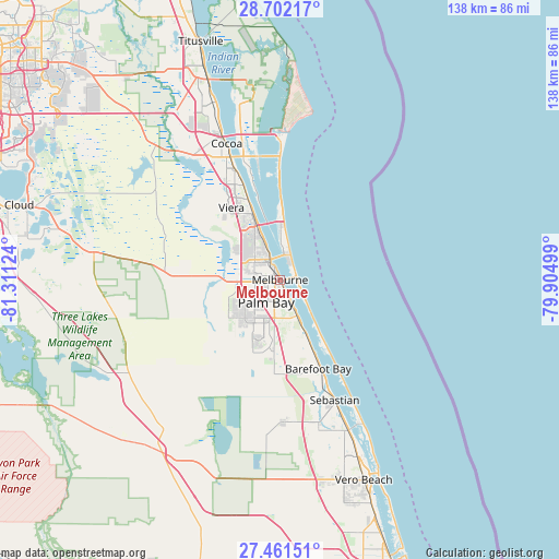
Melbourne GPS coordinates[2]
28° 5' 1.068" North, 80° 36' 29.196" West
| Map corner | latitude | longitude |
|---|---|---|
| Upper-left | 28.70217°, | -81.31124° |
| Center: | 28.08363°, | -80.60811° |
| Lower-right: | 27.46151°, | -79.90499° |
| Map W x H: | 137.9×137.9 km | = 85.7×85.7mi |
| max Lat: | 71.29058° ⇑96.5% North |
| Melbourne: | 28.08363° |
| min Lat: | ⇓3.5% South 19.06759° |
| min Long | Melbourne | max Long |
| -171.73463° | -80.60811° | -66.98998° |
| W 70.5%⇐ | ⇒29.5% E |
Elevation
Elevation of Melbourne is 10 m = 33 ft, and this is 284.8 m = 934 ft below average elevation for this country.
| Max E: |
3189 m = 10463 ft | 93.9% |
| Avg. | 294.8 m = 967 ft | |
| Melbourne | 10 m = 33 ft | |
Min E: |
-60 m = -197 ft | 6.1% |
See also: Melbourne elevation on elevation.city.
Geographical zone
Melbourne is located in North temperate zone (between Tropic of Cancer and the Arctic Circle). Distance of this Northern Tropic circle is 516.7 km =321.1 mi to South.| Distance of | km | miles | from Melbourne |
|---|---|---|---|
| North Pole | 6884.5 | 4277.8 | to North |
| Arctic Circle | 4278.6 | 2658.6 | to North |
| Tropic Cancer | 516.7 | 321.1 | to South |
| Equator | 3122.6 | 1940.3 | to South |


Nearby cities:
15 places around Melbourne: (largest is in red/bold)
• Grant-Valkaria
16.4 km =10.2 mi,  167°
167°
• Indialantic
4.2 km =2.6 mi,  81°
81°
• Indian Harbour Beach
7.5 km =4.7 mi,  14°
14°
• June Park
7.2 km =4.5 mi,  259°
259°
• Malabar
9.8 km =6.1 mi,  154°
154°
• Melbourne Beach
5 km =3.1 mi,  109°
109°
• Melbourne Village
5.7 km =3.5 mi,  271°
271°
• Micco
24.9 km =15.5 mi, 154°
• Palm Bay
5.8 km =3.6 mi,  160°
160°
• Palm Shores
12 km =7.5 mi,  338°
338°
• Satellite Beach
10.4 km =6.5 mi, 9°
• South Patrick Shores
13.2 km =8.2 mi,  359°
359°
• Viera East
22.4 km =13.9 mi,  332°
332°
• Viera West
21.8 km =13.5 mi, 325°
• West Melbourne
4.6 km =2.9 mi,  253°
253°
Sources, notices
• [Note1] Compared only with cities in United States existing in our database
• [Src1] Map data: © OpenStreetMap contributors (CC-BY-SA)
• [Src2] Other city data from geonames.org with taken over terms of usage.
• [Src3] Geographical zone / Annual Mean Temperature by Robert A. Rohde @ Wikipedia
