Palm Shores geodata
Palm Shores (Florida) is a populated place; located in United States in America/New_York (GMT-4) time zone. With population of 900 people, there are 16980 cities with bigger population in this country. Compared to other cities in United States, 96.4% of cities are located further ↑North; 70.4% of cities are located further ←West and 96.6% of cities have higher elevation than Palm Shores. Note1


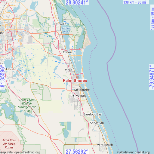
Palm Shores GPS coordinates[2]
28° 11' 4.056" North, 80° 39' 10.188" West
| Map corner | latitude | longitude |
|---|---|---|
| Upper-left | 28.80241°, | -81.35596° |
| Center: | 28.18446°, | -80.65283° |
| Lower-right: | 27.56292°, | -79.94971° |
| Map W x H: | 137.8×137.8 km | = 85.6×85.6mi |
| max Lat: | 71.29058° ⇑96.4% North |
| Palm Shores: | 28.18446° |
| min Lat: | ⇓3.6% South 19.06759° |
| min Long | Palm Shores | max Long |
| -171.73463° | -80.65283° | -66.98998° |
| W 70.4%⇐ | ⇒29.6% E |
Elevation
Elevation of Palm Shores is 7 m = 23 ft, and this is 287.8 m = 944 ft below average elevation for this country.
| Max E: |
3189 m = 10463 ft | 96.6% |
| Avg. | 294.8 m = 967 ft | |
| Palm Shores | 7 m = 23 ft | |
Min E: |
-60 m = -197 ft | 3.4% |
See also: United States elevation on elevation.city.
Geographical zone
Palm Shores is located in North temperate zone (between Tropic of Cancer and the Arctic Circle). Distance of this Northern Tropic circle is 527.9 km =328 mi to South.| Distance of | km | miles | from Palm Shores |
|---|---|---|---|
| North Pole | 6873.2 | 4270.8 | to North |
| Arctic Circle | 4267.4 | 2651.6 | to North |
| Tropic Cancer | 527.9 | 328 | to South |
| Equator | 3133.8 | 1947.3 | to South |


Nearby cities:
15 places around Palm Shores: (largest is in red/bold)
• Cocoa Beach
15.7 km =9.8 mi,  15°
15°
• Indialantic
13.6 km =8.5 mi,  141°
141°
• Indian Harbour Beach
7.5 km =4.7 mi,  122°
122°
• June Park
12.8 km =8 mi,  192°
192°
• Malabar
21.9 km =13.6 mi,  156°
156°
• Melbourne
12 km =7.5 mi, 158°
• Melbourne Beach
15.8 km =9.8 mi, 144°
• Melbourne Village
11.1 km =6.9 mi, 186°
• Palm Bay
17.8 km =11.1 mi, 159°
• Rockledge
19.8 km =12.3 mi,  339°
339°
• Satellite Beach
6.2 km =3.9 mi,  98°
98°
• South Patrick Shores
4.7 km =2.9 mi,  65°
65°
• Viera East
10.6 km =6.6 mi,  325°
325°
• Viera West
10.4 km =6.5 mi,  310°
310°
• West Melbourne
12.5 km =7.8 mi,  180°
180°
Sources, notices
• [Note1] Compared only with cities in United States existing in our database
• [Src1] Map data: © OpenStreetMap contributors (CC-BY-SA)
• [Src2] Other city data from geonames.org with taken over terms of usage.
• [Src3] Geographical zone / Annual Mean Temperature by Robert A. Rohde @ Wikipedia
