Saint Cloud geodata
Saint Cloud (Florida) is a populated place; located in United States in America/New_York (GMT-4) time zone. With population of 35,183 people, there are 1401 cities with bigger population in this country. Compared to other cities in United States, 96.3% of cities are located further ↑North; 68.6% of cities are located further ←West and 86.2% of cities have higher elevation than Saint Cloud. Note1


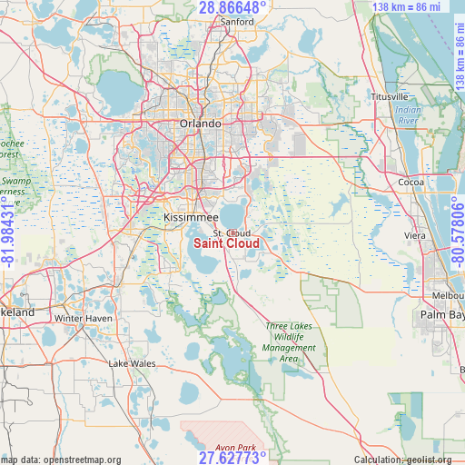
Saint Cloud GPS coordinates[2]
28° 14' 56.04" North, 81° 16' 52.248" West
| Map corner | latitude | longitude |
|---|---|---|
| Upper-left | 28.86648°, | -81.98431° |
| Center: | 28.2489°, | -81.28118° |
| Lower-right: | 27.62773°, | -80.57806° |
| Map W x H: | 137.7×137.7 km | = 85.6×85.6mi |
| max Lat: | 71.29058° ⇑96.3% North |
| Saint Cloud: | 28.2489° |
| min Lat: | ⇓3.7% South 19.06759° |
| min Long | Saint Cloud | max Long |
| -171.73463° | -81.28118° | -66.98998° |
| W 68.6%⇐ | ⇒31.4% E |
Elevation
Elevation of Saint Cloud is 25 m = 82 ft, and this is 269.8 m = 885 ft below average elevation for this country.
| Max E: |
3189 m = 10463 ft | 86.2% |
| Avg. | 294.8 m = 967 ft | |
| Saint Cloud | 25 m = 82 ft | |
Min E: |
-60 m = -197 ft | 13.8% |
See also: United States elevation on elevation.city.
Geographical zone
Saint Cloud is located in North temperate zone (between Tropic of Cancer and the Arctic Circle). Distance of this Northern Tropic circle is 535.1 km =332.5 mi to South.| Distance of | km | miles | from Saint Cloud |
|---|---|---|---|
| North Pole | 6866.1 | 4266.4 | to North |
| Arctic Circle | 4260.2 | 2647.2 | to North |
| Tropic Cancer | 535.1 | 332.5 | to South |
| Equator | 3141 | 1951.7 | to South |


Nearby cities:
15 places around Saint Cloud: (largest is in red/bold)
• Belle Isle
24.5 km =15.2 mi,  341°
341°
• Buenaventura Lakes
12 km =7.5 mi,  323°
323°
• Campbell
17.2 km =10.7 mi,  273°
273°
• Celebration
26.1 km =16.2 mi,  288°
288°
• Edgewood
27.8 km =17.3 mi, 341°
• Hunters Creek
18.6 km =11.6 mi,  311°
311°
• Kissimmee
14.6 km =9.1 mi,  295°
295°
• Lake Hart
16.5 km =10.3 mi,  13°
13°
• Meadow Woods
17.3 km =10.7 mi,  331°
331°
• Pine Castle
26.2 km =16.3 mi, 341°
• Poinciana
21.2 km =13.2 mi,  235°
235°
• Sky Lake
25.6 km =15.9 mi, 335°
• Southchase
18.9 km =11.7 mi, 328°
• Taft
21.7 km =13.5 mi, 337°
• Williamsburg
24.3 km =15.1 mi, 319°
Sources, notices
• [Note1] Compared only with cities in United States existing in our database
• [Src1] Map data: © OpenStreetMap contributors (CC-BY-SA)
• [Src2] Other city data from geonames.org with taken over terms of usage.
• [Src3] Geographical zone / Annual Mean Temperature by Robert A. Rohde @ Wikipedia
