Poinciana geodata
Poinciana (Florida) is a populated place; located in United States in America/New_York (GMT-4) time zone. With population of 53,193 people, there are 877 cities with bigger population in this country. Compared to other cities in United States, 96.4% of cities are located further ↑North; 67.8% of cities are located further ←West and 87.4% of cities have higher elevation than Poinciana. Note1


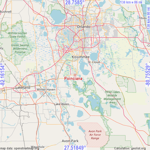
Poinciana GPS coordinates[2]
28° 8' 25.044" North, 81° 27' 30.276" West
| Map corner | latitude | longitude |
|---|---|---|
| Upper-left | 28.7585°, | -82.16154° |
| Center: | 28.14029°, | -81.45841° |
| Lower-right: | 27.51849°, | -80.75529° |
| Map W x H: | 137.9×137.9 km | = 85.7×85.7mi |
| max Lat: | 71.29058° ⇑96.4% North |
| Poinciana: | 28.14029° |
| min Lat: | ⇓3.6% South 19.06759° |
| min Long | Poinciana | max Long |
| -171.73463° | -81.45841° | -66.98998° |
| W 67.8%⇐ | ⇒32.2% E |
Elevation
Elevation of Poinciana is 22 m = 72 ft, and this is 272.8 m = 895 ft below average elevation for this country.
| Max E: |
3189 m = 10463 ft | 87.4% |
| Avg. | 294.8 m = 967 ft | |
| Poinciana | 22 m = 72 ft | |
Min E: |
-60 m = -197 ft | 12.6% |
See also: Poinciana elevation on elevation.city.
Geographical zone
Poinciana is located in North temperate zone (between Tropic of Cancer and the Arctic Circle). Distance of this Northern Tropic circle is 523 km =325 mi to South.| Distance of | km | miles | from Poinciana |
|---|---|---|---|
| North Pole | 6878.2 | 4273.9 | to North |
| Arctic Circle | 4272.3 | 2654.7 | to North |
| Tropic Cancer | 523 | 325 | to South |
| Equator | 3128.9 | 1944.2 | to South |


Nearby cities:
15 places around Poinciana: (largest is in red/bold)
• Buenaventura Lakes
24.1 km =15 mi,  25°
25°
• Campbell
13.2 km =8.2 mi,  0°
0°
• Celebration
21.8 km =13.5 mi,  340°
340°
• Citrus Ridge
28.1 km =17.5 mi,  320°
320°
• Cypress Gardens
28 km =17.4 mi,  234°
234°
• Davenport
14.2 km =8.8 mi,  279°
279°
• Dundee
20.5 km =12.7 mi, 230°
• Haines City
16.1 km =10 mi,  259°
259°
• Hunters Creek
24.7 km =15.3 mi,  8°
8°
• Kissimmee
18.7 km =11.6 mi, 12°
• Lake Alfred
26.5 km =16.5 mi, 258°
• Lake Hamilton
19.7 km =12.2 mi,  237°
237°
• Loughman
15.5 km =9.6 mi, 316°
• Saint Cloud
21.2 km =13.2 mi,  55°
55°
• Waverly
23.6 km =14.7 mi,  220°
220°
Sources, notices
• [Note1] Compared only with cities in United States existing in our database
• [Src1] Map data: © OpenStreetMap contributors (CC-BY-SA)
• [Src2] Other city data from geonames.org with taken over terms of usage.
• [Src3] Geographical zone / Annual Mean Temperature by Robert A. Rohde @ Wikipedia
