Saint George geodata
Saint George (Florida) is a populated place; located in United States in America/New_York (GMT-4) time zone. With population of 2,709 people, there are 10162 cities with bigger population in this country. Compared to other cities in United States, 96.5% of cities are located further ↑North; 62.8% of cities are located further ←West and 86.6% of cities have higher elevation than Saint George. Note1


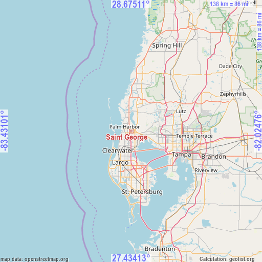
Saint George GPS coordinates[2]
28° 3' 23.076" North, 82° 43' 40.368" West
| Map corner | latitude | longitude |
|---|---|---|
| Upper-left | 28.67511°, | -83.43101° |
| Center: | 28.05641°, | -82.72788° |
| Lower-right: | 27.43413°, | -82.02476° |
| Map W x H: | 138×138 km | = 85.7×85.7mi |
| max Lat: | 71.29058° ⇑96.5% North |
| Saint George: | 28.05641° |
| min Lat: | ⇓3.5% South 19.06759° |
| min Long | Saint George | max Long |
| -171.73463° | -82.72788° | -66.98998° |
| W 62.8%⇐ | ⇒37.2% E |
Elevation
Elevation of Saint George is 24 m = 79 ft, and this is 270.8 m = 888 ft below average elevation for this country.
| Max E: |
3189 m = 10463 ft | 86.6% |
| Avg. | 294.8 m = 967 ft | |
| Saint George | 24 m = 79 ft | |
Min E: |
-60 m = -197 ft | 13.4% |
See also: United States elevation on elevation.city.
Geographical zone
Saint George is located in North temperate zone (between Tropic of Cancer and the Arctic Circle). Distance of this Northern Tropic circle is 513.7 km =319.2 mi to South.| Distance of | km | miles | from Saint George |
|---|---|---|---|
| North Pole | 6887.5 | 4279.7 | to North |
| Arctic Circle | 4281.6 | 2660.5 | to North |
| Tropic Cancer | 513.7 | 319.2 | to South |
| Equator | 3119.6 | 1938.4 | to South |


Nearby cities:
15 places around Saint George: (largest is in red/bold)
• Belleair
15.5 km =9.6 mi,  209°
209°
• Clearwater
12.3 km =7.6 mi,  215°
215°
• Dunedin
6 km =3.7 mi,  227°
227°
• East Lake
6.9 km =4.3 mi,  28°
28°
• Greenbriar
5.6 km =3.5 mi, 205°
• Holiday
14.7 km =9.1 mi,  355°
355°
• Keystone
15.2 km =9.4 mi,  43°
43°
• Oldsmar
6.6 km =4.1 mi,  111°
111°
• Palm Harbor
4.3 km =2.7 mi,  304°
304°
• Safety Harbor
8 km =5 mi,  154°
154°
• South Highpoint
15.6 km =9.7 mi,  174°
174°
• Tarpon Springs
10.4 km =6.5 mi,  344°
344°
• Town 'n' Country
15.6 km =9.7 mi, 109°
• Trinity
14.6 km =9.1 mi,  18°
18°
• Westchase
11.6 km =7.2 mi,  90°
90°
Sources, notices
• [Note1] Compared only with cities in United States existing in our database
• [Src1] Map data: © OpenStreetMap contributors (CC-BY-SA)
• [Src2] Other city data from geonames.org with taken over terms of usage.
• [Src3] Geographical zone / Annual Mean Temperature by Robert A. Rohde @ Wikipedia
