Clearwater geodata
Clearwater (Florida) is a seat of a second-order administrative division; located in United States in America/New_York (GMT-4) time zone. With population of 113,003 people, there are 287 cities with bigger population in this country. Compared to other cities in United States, 96.7% of cities are located further ↑North; 62.6% of cities are located further ←West and 90.5% of cities have higher elevation than Clearwater. Note1


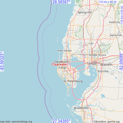
Clearwater GPS coordinates[2]
27° 57' 57.06" North, 82° 48' 0.36" West
| Map corner | latitude | longitude |
|---|---|---|
| Upper-left | 28.58507°, | -83.50323° |
| Center: | 27.96585°, | -82.8001° |
| Lower-right: | 27.34305°, | -82.09698° |
| Map W x H: | 138.1×138.1 km | = 85.8×85.8mi |
| max Lat: | 71.29058° ⇑96.7% North |
| Clearwater: | 27.96585° |
| min Lat: | ⇓3.3% South 19.06759° |
| min Long | Clearwater | max Long |
| -171.73463° | -82.8001° | -66.98998° |
| W 62.6%⇐ | ⇒37.4% E |
Elevation
Elevation of Clearwater is 15 m = 49 ft, and this is 279.8 m = 918 ft below average elevation for this country.
| Max E: |
3189 m = 10463 ft | 90.5% |
| Avg. | 294.8 m = 967 ft | |
| Clearwater | 15 m = 49 ft | |
Min E: |
-60 m = -197 ft | 9.5% |
See also: Clearwater elevation on elevation.city.
Geographical zone
Clearwater is located in North temperate zone (between Tropic of Cancer and the Arctic Circle). Distance of this Northern Tropic circle is 503.6 km =312.9 mi to South.| Distance of | km | miles | from Clearwater |
|---|---|---|---|
| North Pole | 6897.6 | 4286 | to North |
| Arctic Circle | 4291.7 | 2666.7 | to North |
| Tropic Cancer | 503.6 | 312.9 | to South |
| Equator | 3109.5 | 1932.2 | to South |


Nearby cities:
15 places around Clearwater: (largest is in red/bold)
• Belleair
3.4 km =2.1 mi,  190°
190°
• Belleair Beach
6.4 km =4 mi,  221°
221°
• Belleair Bluffs
5.2 km =3.2 mi,  198°
198°
• Dunedin
6.6 km =4.1 mi,  23°
23°
• Greenbriar
6.9 km =4.3 mi,  42°
42°
• Harbor Bluffs
6.8 km =4.2 mi, 203°
• Indian Rocks Beach
11.3 km =7 mi,  206°
206°
• Indian Shores
12.4 km =7.7 mi, 202°
• Largo
6.3 km =3.9 mi,  169°
169°
• Palm Harbor
13 km =8.1 mi, 15°
• Ridgecrest
7.6 km =4.7 mi,  183°
183°
• Safety Harbor
10.9 km =6.8 mi,  75°
75°
• Saint George
12.3 km =7.6 mi, 35°
• Seminole
14 km =8.7 mi, 176°
• South Highpoint
10.1 km =6.3 mi,  122°
122°
Sources, notices
• [Note1] Compared only with cities in United States existing in our database
• [Src1] Map data: © OpenStreetMap contributors (CC-BY-SA)
• [Src2] Other city data from geonames.org with taken over terms of usage.
• [Src3] Geographical zone / Annual Mean Temperature by Robert A. Rohde @ Wikipedia
