Seaside geodata
Seaside (Florida) is a populated place; located in United States in America/Chicago (GMT-5) time zone. With population of 2,000 people, there are 11941 cities with bigger population in this country. Compared to other cities in United States, 92.4% of cities are located further ↑North; 52.5% of cities are located further ←West and 93.9% of cities have higher elevation than Seaside. Note1


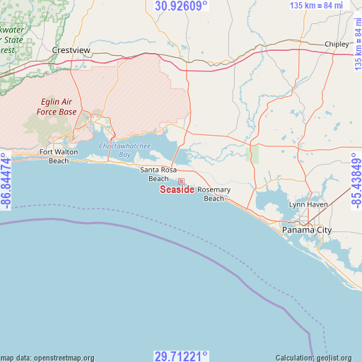
Seaside GPS coordinates[2]
30° 19' 15.708" North, 86° 8' 29.796" West
| Map corner | latitude | longitude |
|---|---|---|
| Upper-left | 30.92609°, | -86.84474° |
| Center: | 30.32103°, | -86.14161° |
| Lower-right: | 29.71221°, | -85.43849° |
| Map W x H: | 135×135 km | = 83.9×83.9mi |
| max Lat: | 71.29058° ⇑92.4% North |
| Seaside: | 30.32103° |
| min Lat: | ⇓7.6% South 19.06759° |
| min Long | Seaside | max Long |
| -171.73463° | -86.14161° | -66.98998° |
| W 52.5%⇐ | ⇒47.5% E |
Elevation
Elevation of Seaside is 10 m = 33 ft, and this is 284.8 m = 934 ft below average elevation for this country.
| Max E: |
3189 m = 10463 ft | 93.9% |
| Avg. | 294.8 m = 967 ft | |
| Seaside | 10 m = 33 ft | |
Min E: |
-60 m = -197 ft | 6.1% |
See also: United States elevation on elevation.city.
Geographical zone
Seaside is located in North temperate zone (between Tropic of Cancer and the Arctic Circle). Distance of this Northern Tropic circle is 765.5 km =475.7 mi to South.| Distance of | km | miles | from Seaside |
|---|---|---|---|
| North Pole | 6635.7 | 4123.2 | to North |
| Arctic Circle | 4029.8 | 2504 | to North |
| Tropic Cancer | 765.5 | 475.7 | to South |
| Equator | 3371.4 | 2094.9 | to South |


Nearby cities:
15 places around Seaside: (largest is in red/bold)
• DeFuniak Springs
44.5 km =27.7 mi,  3°
3°
• Destin
34.9 km =21.7 mi,  283°
283°
• Eglin Air Force Base
42.1 km =26.2 mi,  291°
291°
• Eglin Village
41.3 km =25.7 mi, 292°
• Freeport
19.7 km =12.2 mi, 1°
• Laguna Beach
22.8 km =14.2 mi,  113°
113°
• Lake Lorraine
42.8 km =26.6 mi, 288°
• Lower Grand Lagoon
42.4 km =26.3 mi,  117°
117°
• Miramar Beach
21.6 km =13.4 mi, 285°
• Niceville
39.2 km =24.4 mi,  303°
303°
• Panama City Beach
36.1 km =22.4 mi, 116°
• Pretty Bayou
44.9 km =27.9 mi, 107°
• Shalimar
44.2 km =27.5 mi, 288°
• Upper Grand Lagoon
42.3 km =26.3 mi, 114°
• Valparaiso
40.4 km =25.1 mi, 301°
Sources, notices
• [Note1] Compared only with cities in United States existing in our database
• [Src1] Map data: © OpenStreetMap contributors (CC-BY-SA)
• [Src2] Other city data from geonames.org with taken over terms of usage.
• [Src3] Geographical zone / Annual Mean Temperature by Robert A. Rohde @ Wikipedia
