Niceville geodata
Niceville (Florida) is a populated place; located in United States in America/Chicago (GMT-5) time zone. With population of 14,714 people, there are 3294 cities with bigger population in this country. Compared to other cities in United States, 91.7% of cities are located further ↑North; 51.6% of cities are located further ←West and 88.6% of cities have higher elevation than Niceville. Note1


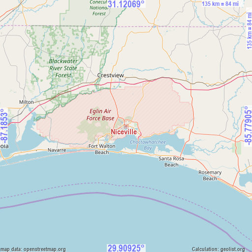
Niceville GPS coordinates[2]
30° 31' 0.696" North, 86° 28' 55.812" West
| Map corner | latitude | longitude |
|---|---|---|
| Upper-left | 31.12069°, | -87.1853° |
| Center: | 30.51686°, | -86.48217° |
| Lower-right: | 29.90925°, | -85.77905° |
| Map W x H: | 134.7×134.7 km | = 83.7×83.7mi |
| max Lat: | 71.29058° ⇑91.7% North |
| Niceville: | 30.51686° |
| min Lat: | ⇓8.3% South 19.06759° |
| min Long | Niceville | max Long |
| -171.73463° | -86.48217° | -66.98998° |
| W 51.6%⇐ | ⇒48.4% E |
Elevation
Elevation of Niceville is 19 m = 62 ft, and this is 275.8 m = 905 ft below average elevation for this country.
| Max E: |
3189 m = 10463 ft | 88.6% |
| Avg. | 294.8 m = 967 ft | |
| Niceville | 19 m = 62 ft | |
Min E: |
-60 m = -197 ft | 11.4% |
See also: United States elevation on elevation.city.
Geographical zone
Niceville is located in North temperate zone (between Tropic of Cancer and the Arctic Circle). Distance of this Northern Tropic circle is 787.2 km =489.1 mi to South.| Distance of | km | miles | from Niceville |
|---|---|---|---|
| North Pole | 6613.9 | 4109.7 | to North |
| Arctic Circle | 4008 | 2490.5 | to North |
| Tropic Cancer | 787.2 | 489.1 | to South |
| Equator | 3393.2 | 2108.4 | to South |


Nearby cities:
15 places around Niceville: (largest is in red/bold)
• Crestview
28.6 km =17.8 mi,  342°
342°
• Destin
13.8 km =8.6 mi,  185°
185°
• Eglin Air Force Base
9.2 km =5.7 mi,  225°
225°
• Eglin Village
8.1 km =5 mi,  222°
222°
• Fort Walton Beach
16.8 km =10.4 mi, 230°
• Freeport
33.2 km =20.6 mi,  93°
93°
• Lake Lorraine
11.5 km =7.1 mi, 223°
• Mary Esther
21.2 km =13.2 mi,  235°
235°
• Miramar Beach
19.8 km =12.3 mi,  143°
143°
• Navarre
38.7 km =24 mi,  250°
250°
• Ocean City
15.2 km =9.4 mi, 236°
• Seaside
39.2 km =24.4 mi,  123°
123°
• Shalimar
12.2 km =7.6 mi, 229°
• Valparaiso
2.2 km =1.4 mi, 244°
• Wright
16.4 km =10.2 mi, 245°
Sources, notices
• [Note1] Compared only with cities in United States existing in our database
• [Src1] Map data: © OpenStreetMap contributors (CC-BY-SA)
• [Src2] Other city data from geonames.org with taken over terms of usage.
• [Src3] Geographical zone / Annual Mean Temperature by Robert A. Rohde @ Wikipedia
