South Brooksville geodata
South Brooksville (Florida) is a populated place; located in United States in America/New_York (GMT-4) time zone. With population of 4,007 people, there are 8209 cities with bigger population in this country. Compared to other cities in United States, 95.9% of cities are located further ↑North; 64.4% of cities are located further ←West and 78.8% of cities have higher elevation than South Brooksville. Note1


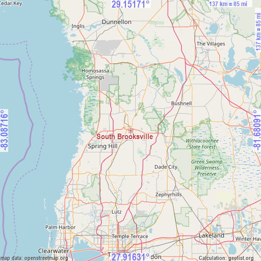
South Brooksville GPS coordinates[2]
28° 32' 8.952" North, 82° 23' 2.508" West
| Map corner | latitude | longitude |
|---|---|---|
| Upper-left | 29.15171°, | -83.08716° |
| Center: | 28.53582°, | -82.38403° |
| Lower-right: | 27.91631°, | -81.68091° |
| Map W x H: | 137.4×137.4 km | = 85.4×85.4mi |
| max Lat: | 71.29058° ⇑95.9% North |
| South Brooksville: | 28.53582° |
| min Lat: | ⇓4.1% South 19.06759° |
| min Long | South Brooksvil | max Long |
| -171.73463° | -82.38403° | -66.98998° |
| W 64.4%⇐ | ⇒35.6% E |
Elevation
Elevation of South Brooksville is 52 m = 171 ft, and this is 242.8 m = 797 ft below average elevation for this country.
| Max E: |
3189 m = 10463 ft | 78.8% |
| Avg. | 294.8 m = 967 ft | |
| South Brooksville | 52 m = 171 ft | |
Min E: |
-60 m = -197 ft | 21.2% |
See also: United States elevation on elevation.city.
Geographical zone
South Brooksville is located in North temperate zone (between Tropic of Cancer and the Arctic Circle). Distance of this Northern Tropic circle is 567 km =352.3 mi to South.| Distance of | km | miles | from South Brooksville |
|---|---|---|---|
| North Pole | 6834.2 | 4246.6 | to North |
| Arctic Circle | 4228.3 | 2627.3 | to North |
| Tropic Cancer | 567 | 352.3 | to South |
| Equator | 3172.9 | 1971.5 | to South |


Nearby cities:
15 places around South Brooksville: (largest is in red/bold)
• Brookridge
10.7 km =6.6 mi,  279°
279°
• Brooksville
2.3 km =1.4 mi,  345°
345°
• Garden Grove
7.9 km =4.9 mi,  218°
218°
• High Point
13.8 km =8.6 mi, 275°
• Hill 'n Dale
8.5 km =5.3 mi,  102°
102°
• Lacoochee
22.1 km =13.7 mi,  110°
110°
• Masaryktown
12.7 km =7.9 mi,  214°
214°
• North Brooksville
4.8 km =3 mi,  330°
330°
• North Weeki Wachee
17.2 km =10.7 mi, 275°
• Ridge Manor
21.1 km =13.1 mi, 98°
• Shady Hills
20.9 km =13 mi,  227°
227°
• Spring Hill
15.3 km =9.5 mi,  244°
244°
• Timber Pines
22.6 km =14 mi,  251°
251°
• Weeki Wachee Gardens
24 km =14.9 mi,  269°
269°
• Wiscon
7.6 km =4.7 mi, 274°
Sources, notices
• [Note1] Compared only with cities in United States existing in our database
• [Src1] Map data: © OpenStreetMap contributors (CC-BY-SA)
• [Src2] Other city data from geonames.org with taken over terms of usage.
• [Src3] Geographical zone / Annual Mean Temperature by Robert A. Rohde @ Wikipedia
