Utopia geodata
Utopia (Florida) is a populated place; located in United States in America/New_York (GMT-4) time zone. With population of 732 people, there are 18385 cities with bigger population in this country. Compared to other cities in United States, 97.4% of cities are located further ↑North; 64.4% of cities are located further ←West and 90.5% of cities have higher elevation than Utopia. Note1


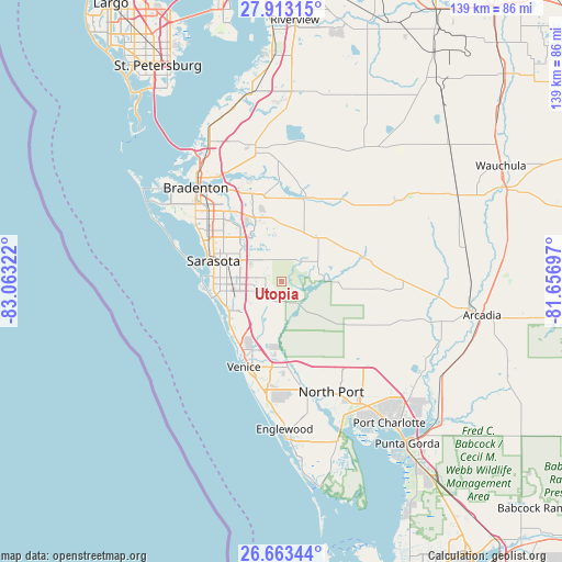
Utopia GPS coordinates[2]
27° 17' 24.18" North, 82° 21' 36.324" West
| Map corner | latitude | longitude |
|---|---|---|
| Upper-left | 27.91315°, | -83.06322° |
| Center: | 27.29005°, | -82.36009° |
| Lower-right: | 26.66344°, | -81.65697° |
| Map W x H: | 139×139 km | = 86.4×86.4mi |
| max Lat: | 71.29058° ⇑97.4% North |
| Utopia: | 27.29005° |
| min Lat: | ⇓2.6% South 19.06759° |
| min Long | Utopia | max Long |
| -171.73463° | -82.36009° | -66.98998° |
| W 64.4%⇐ | ⇒35.6% E |
Elevation
Elevation of Utopia is 15 m = 49 ft, and this is 279.8 m = 918 ft below average elevation for this country.
| Max E: |
3189 m = 10463 ft | 90.5% |
| Avg. | 294.8 m = 967 ft | |
| Utopia | 15 m = 49 ft | |
Min E: |
-60 m = -197 ft | 9.5% |
See also: United States elevation on elevation.city.
Geographical zone
Utopia is located in North temperate zone (between Tropic of Cancer and the Arctic Circle). Distance of this Northern Tropic circle is 428.5 km =266.3 mi to South.| Distance of | km | miles | from Utopia |
|---|---|---|---|
| North Pole | 6972.7 | 4332.6 | to North |
| Arctic Circle | 4366.8 | 2713.4 | to North |
| Tropic Cancer | 428.5 | 266.3 | to South |
| Equator | 3034.4 | 1885.5 | to South |


Nearby cities:
15 places around Utopia: (largest is in red/bold)
• Bee Ridge
11.9 km =7.4 mi,  266°
266°
• Desoto Lakes
15.7 km =9.8 mi,  305°
305°
• Fruitville
10.6 km =6.6 mi,  294°
294°
• Gulf Gate Estates
15.9 km =9.9 mi,  254°
254°
• Kensington Park
15.5 km =9.6 mi,  299°
299°
• Lake Sarasota
7.7 km =4.8 mi, 272°
• Osprey
16.6 km =10.3 mi,  230°
230°
• Ridge Wood Heights
15.1 km =9.4 mi, 268°
• Sarasota
17.6 km =10.9 mi, 287°
• Sarasota Springs
12 km =7.5 mi,  280°
280°
• South Gate Ridge
13.5 km =8.4 mi, 268°
• South Sarasota
17.1 km =10.6 mi, 268°
• Southgate
14.9 km =9.3 mi, 277°
• The Meadows
13.4 km =8.3 mi, 306°
• Vamo
15.6 km =9.7 mi,  240°
240°
Sources, notices
• [Note1] Compared only with cities in United States existing in our database
• [Src1] Map data: © OpenStreetMap contributors (CC-BY-SA)
• [Src2] Other city data from geonames.org with taken over terms of usage.
• [Src3] Geographical zone / Annual Mean Temperature by Robert A. Rohde @ Wikipedia
