Clarkesville geodata
Clarkesville (Georgia) is a seat of a second-order administrative division; located in United States in America/New_York (GMT-4) time zone. With population of 1,746 people, there are 12753 cities with bigger population in this country. Compared to other cities in United States, 77.2% of cities are located further ↑North; 60.5% of cities are located further ←West and 84.9% of cities have lower elevation than Clarkesville. Note1


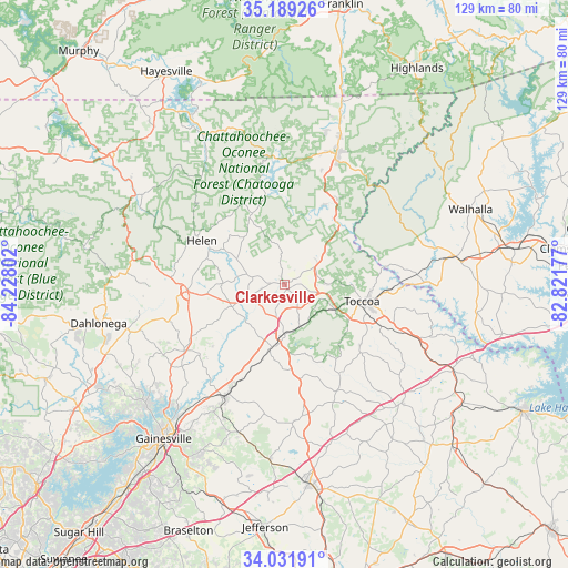
Clarkesville GPS coordinates[2]
34° 36' 45.36" North, 83° 31' 29.604" West
| Map corner | latitude | longitude |
|---|---|---|
| Upper-left | 35.18926°, | -84.22802° |
| Center: | 34.6126°, | -83.52489° |
| Lower-right: | 34.03191°, | -82.82177° |
| Map W x H: | 128.7×128.7 km | = 80×80mi |
| max Lat: | 71.29058° ⇑77.2% North |
| Clarkesville: | 34.6126° |
| min Lat: | ⇓22.8% South 19.06759° |
| min Long | Clarkesville | max Long |
| -171.73463° | -83.52489° | -66.98998° |
| W 60.5%⇐ | ⇒39.5% E |
Elevation
Elevation of Clarkesville is 422 m = 1385 ft, and this is 127.2 m = 417 ft above average elevation for this country.
| Max E: |
3189 m = 10463 ft | 15.1% |
| Clarkesville | 422 m 1385 ft | |
| Avg. | 294.8 m = 967 ft | |
Min E: |
-60 m = -197 ft | 84.9% |
See also: United States elevation on elevation.city.
Geographical zone
Clarkesville is located in North temperate zone (between Tropic of Cancer and the Arctic Circle). Distance of this Northern Tropic circle is 1242.6 km =772.1 mi to South.| Distance of | km | miles | from Clarkesville |
|---|---|---|---|
| North Pole | 6158.5 | 3826.7 | to North |
| Arctic Circle | 3552.6 | 2207.5 | to North |
| Tropic Cancer | 1242.6 | 772.1 | to South |
| Equator | 3848.6 | 2391.4 | to South |


Nearby cities:
15 places around Clarkesville: (largest is in red/bold)
• Alto
16.8 km =10.4 mi,  195°
195°
• Baldwin
13.5 km =8.4 mi,  184°
184°
• Clayton
31.6 km =19.6 mi,  20°
20°
• Clermont
27.3 km =17 mi,  236°
236°
• Cleveland
21.9 km =13.6 mi,  265°
265°
• Cornelia
11.2 km =7 mi, 181°
• Demorest
5.6 km =3.5 mi, 199°
• Helen
21.3 km =13.2 mi,  297°
297°
• Homer
31.1 km =19.3 mi, 175°
• Lula
28.2 km =17.5 mi,  207°
207°
• Mount Airy
10.7 km =6.6 mi,  168°
168°
• Mountain City
36.3 km =22.6 mi, 20°
• Raoul
19.2 km =11.9 mi, 199°
• Toccoa
18.1 km =11.2 mi,  102°
102°
• Yonah
21.2 km =13.2 mi,  278°
278°
Sources, notices
• [Note1] Compared only with cities in United States existing in our database
• [Src1] Map data: © OpenStreetMap contributors (CC-BY-SA)
• [Src2] Other city data from geonames.org with taken over terms of usage.
• [Src3] Geographical zone / Annual Mean Temperature by Robert A. Rohde @ Wikipedia
