Toccoa geodata
Toccoa (Georgia) is a seat of a second-order administrative division; located in United States in America/New_York (GMT-4) time zone. With population of 8,283 people, there are 5145 cities with bigger population in this country. Compared to other cities in United States, 77.4% of cities are located further ↑North; 61.1% of cities are located further ←West and 73.8% of cities have lower elevation than Toccoa. Note1


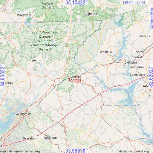
Toccoa GPS coordinates[2]
34° 34' 38.352" North, 83° 19' 56.604" West
| Map corner | latitude | longitude |
|---|---|---|
| Upper-left | 35.15422°, | -84.03552° |
| Center: | 34.57732°, | -83.33239° |
| Lower-right: | 33.99638°, | -82.62927° |
| Map W x H: | 128.7×128.7 km | = 80×80mi |
| max Lat: | 71.29058° ⇑77.4% North |
| Toccoa: | 34.57732° |
| min Lat: | ⇓22.6% South 19.06759° |
| min Long | Toccoa | max Long |
| -171.73463° | -83.33239° | -66.98998° |
| W 61.1%⇐ | ⇒38.9% E |
Elevation
Elevation of Toccoa is 306 m = 1004 ft, and this is 11.2 m = 37 ft above average elevation for this country.
| Max E: |
3189 m = 10463 ft | 26.2% |
| Toccoa | 306 m 1004 ft | |
| Avg. | 294.8 m = 967 ft | |
Min E: |
-60 m = -197 ft | 73.8% |
See also: United States elevation on elevation.city.
Geographical zone
Toccoa is located in North temperate zone (between Tropic of Cancer and the Arctic Circle). Distance of this Northern Tropic circle is 1238.7 km =769.7 mi to South.| Distance of | km | miles | from Toccoa |
|---|---|---|---|
| North Pole | 6162.4 | 3829.1 | to North |
| Arctic Circle | 3556.5 | 2209.9 | to North |
| Tropic Cancer | 1238.7 | 769.7 | to South |
| Equator | 3844.6 | 2388.9 | to South |


Nearby cities:
15 places around Toccoa: (largest is in red/bold)
• Alto
25.3 km =15.7 mi,  241°
241°
• Baldwin
21 km =13 mi, 243°
• Canon
32.8 km =20.4 mi,  141°
141°
• Carnesville
24.7 km =15.3 mi,  158°
158°
• Clarkesville
18.1 km =11.2 mi,  282°
282°
• Cornelia
19.3 km =12 mi,  247°
247°
• Demorest
19.5 km =12.1 mi,  266°
266°
• Fair Play
32.6 km =20.3 mi,  103°
103°
• Gumlog
23.6 km =14.7 mi,  113°
113°
• Homer
31.1 km =19.3 mi,  209°
209°
• Lavonia
26 km =16.2 mi,  127°
127°
• Mount Airy
16.7 km =10.4 mi, 247°
• Raoul
27.9 km =17.3 mi, 239°
• Walhalla
32.2 km =20 mi,  49°
49°
• Westminster
23.7 km =14.7 mi,  65°
65°
Sources, notices
• [Note1] Compared only with cities in United States existing in our database
• [Src1] Map data: © OpenStreetMap contributors (CC-BY-SA)
• [Src2] Other city data from geonames.org with taken over terms of usage.
• [Src3] Geographical zone / Annual Mean Temperature by Robert A. Rohde @ Wikipedia
