Cohutta geodata
Cohutta (Georgia) is a populated place; located in United States in America/New_York (GMT-4) time zone. With population of 637 people, there are 19293 cities with bigger population in this country. Compared to other cities in United States, 75.6% of cities are located further ↑North; 56% of cities are located further ←West and 65% of cities have lower elevation than Cohutta. Note1


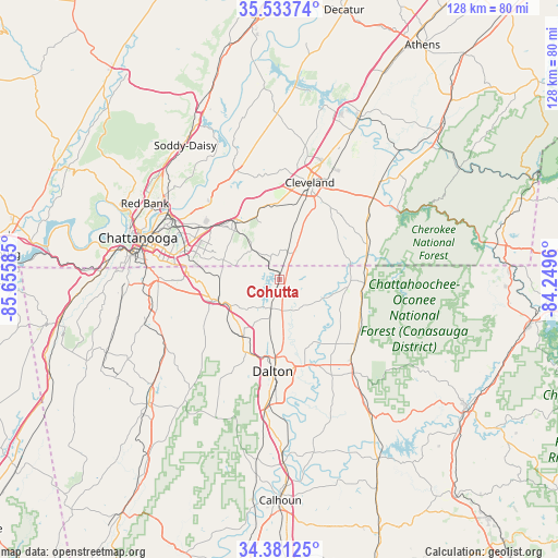
Cohutta GPS coordinates[2]
34° 57' 34.272" North, 84° 57' 9.792" West
| Map corner | latitude | longitude |
|---|---|---|
| Upper-left | 35.53374°, | -85.65585° |
| Center: | 34.95952°, | -84.95272° |
| Lower-right: | 34.38125°, | -84.2496° |
| Map W x H: | 128.1×128.1 km | = 79.6×79.6mi |
| max Lat: | 71.29058° ⇑75.6% North |
| Cohutta: | 34.95952° |
| min Lat: | ⇓24.4% South 19.06759° |
| min Long | Cohutta | max Long |
| -171.73463° | -84.95272° | -66.98998° |
| W 56%⇐ | ⇒44% E |
Elevation
Elevation of Cohutta is 262 m = 860 ft, and this is 32.8 m = 108 ft below average elevation for this country.
| Max E: |
3189 m = 10463 ft | 35% |
| Avg. | 294.8 m = 967 ft | |
| Cohutta | 262 m = 860 ft | |
Min E: |
-60 m = -197 ft | 65% |
See also: United States elevation on elevation.city.
Geographical zone
Cohutta is located in North temperate zone (between Tropic of Cancer and the Arctic Circle). Distance of this Northern Tropic circle is 1281.2 km =796.1 mi to South.| Distance of | km | miles | from Cohutta |
|---|---|---|---|
| North Pole | 6119.9 | 3802.7 | to North |
| Arctic Circle | 3514 | 2183.5 | to North |
| Tropic Cancer | 1281.2 | 796.1 | to South |
| Equator | 3887.1 | 2415.3 | to South |


Nearby cities:
15 places around Cohutta: (largest is in red/bold)
• Apison
9.7 km =6 mi,  317°
317°
• Cleveland
23.3 km =14.5 mi,  17°
17°
• Collegedale
13.7 km =8.5 mi, 319°
• Dalton
21.2 km =13.2 mi,  184°
184°
• East Brainerd
18.4 km =11.4 mi,  282°
282°
• East Cleveland
24 km =14.9 mi, 21°
• Eton
22.8 km =14.2 mi,  130°
130°
• Harrison
24 km =14.9 mi, 315°
• Indian Springs
19.3 km =12 mi,  269°
269°
• Ooltewah
16.3 km =10.1 mi, 322°
• Ringgold
15.1 km =9.4 mi,  251°
251°
• South Cleveland
21.5 km =13.4 mi, 19°
• Tunnel Hill
15.6 km =9.7 mi,  211°
211°
• Varnell
6.8 km =4.2 mi,  196°
196°
• Wildwood Lake
17.2 km =10.7 mi,  31°
31°
Sources, notices
• [Note1] Compared only with cities in United States existing in our database
• [Src1] Map data: © OpenStreetMap contributors (CC-BY-SA)
• [Src2] Other city data from geonames.org with taken over terms of usage.
• [Src3] Geographical zone / Annual Mean Temperature by Robert A. Rohde @ Wikipedia
