Cleveland geodata
Cleveland (Tennessee) is a seat of a second-order administrative division; located in United States in America/New_York (GMT-4) time zone. With population of 43,898 people, there are 1087 cities with bigger population in this country. Compared to other cities in United States, 74.5% of cities are located further ↑North; 56.1% of cities are located further ←West and 64.8% of cities have lower elevation than Cleveland. Note1


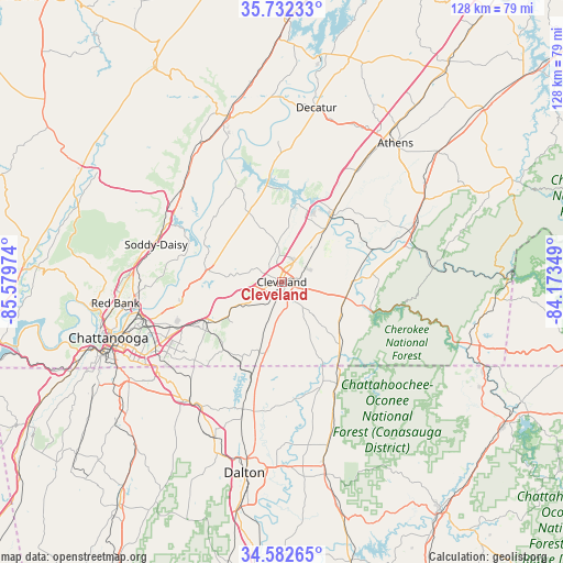
Cleveland GPS coordinates[2]
35° 9' 34.272" North, 84° 52' 35.796" West
| Map corner | latitude | longitude |
|---|---|---|
| Upper-left | 35.73233°, | -85.57974° |
| Center: | 35.15952°, | -84.87661° |
| Lower-right: | 34.58265°, | -84.17349° |
| Map W x H: | 127.8×127.8 km | = 79.4×79.4mi |
| max Lat: | 71.29058° ⇑74.5% North |
| Cleveland: | 35.15952° |
| min Lat: | ⇓25.5% South 19.06759° |
| min Long | Cleveland | max Long |
| -171.73463° | -84.87661° | -66.98998° |
| W 56.1%⇐ | ⇒43.9% E |
Elevation
Elevation of Cleveland is 261 m = 856 ft, and this is 33.8 m = 111 ft below average elevation for this country.
| Max E: |
3189 m = 10463 ft | 35.2% |
| Avg. | 294.8 m = 967 ft | |
| Cleveland | 261 m = 856 ft | |
Min E: |
-60 m = -197 ft | 64.8% |
See also: Cleveland elevation on elevation.city.
Geographical zone
Cleveland is located in North temperate zone (between Tropic of Cancer and the Arctic Circle). Distance of this Northern Tropic circle is 1303.5 km =810 mi to South.| Distance of | km | miles | from Cleveland |
|---|---|---|---|
| North Pole | 6097.7 | 3788.9 | to North |
| Arctic Circle | 3491.8 | 2169.7 | to North |
| Tropic Cancer | 1303.5 | 810 | to South |
| Equator | 3909.4 | 2429.2 | to South |


Nearby cities:
15 places around Cleveland: (largest is in red/bold)
• Apison
20.2 km =12.6 mi,  221°
221°
• Benton
20.3 km =12.6 mi,  85°
85°
• Charleston
17.8 km =11.1 mi,  37°
37°
• Cohutta
23.3 km =14.5 mi,  197°
197°
• Collegedale
19.7 km =12.2 mi,  233°
233°
• East Cleveland
1.7 km =1.1 mi,  84°
84°
• Harrison
24.3 km =15.1 mi,  257°
257°
• Hopewell
8.4 km =5.2 mi,  352°
352°
• Lakesite
23.4 km =14.5 mi,  283°
283°
• Middle Valley
28.3 km =17.6 mi, 278°
• Ooltewah
19.3 km =12 mi,  240°
240°
• Riceville
30.1 km =18.7 mi,  33°
33°
• Soddy-Daisy
29.8 km =18.5 mi,  286°
286°
• South Cleveland
2.1 km =1.3 mi,  168°
168°
• Wildwood Lake
7.8 km =4.8 mi,  164°
164°
Sources, notices
• [Note1] Compared only with cities in United States existing in our database
• [Src1] Map data: © OpenStreetMap contributors (CC-BY-SA)
• [Src2] Other city data from geonames.org with taken over terms of usage.
• [Src3] Geographical zone / Annual Mean Temperature by Robert A. Rohde @ Wikipedia
