Pooler geodata
Pooler (Georgia) is a populated place; located in United States in America/New_York (GMT-4) time zone. With population of 23,133 people, there are 2177 cities with bigger population in this country. Compared to other cities in United States, 88.3% of cities are located further ↑North; 68.7% of cities are located further ←West and 93.9% of cities have higher elevation than Pooler. Note1


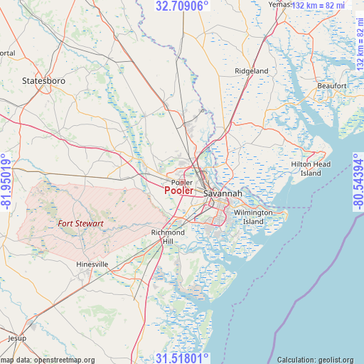
Pooler GPS coordinates[2]
32° 6' 55.728" North, 81° 14' 49.416" West
| Map corner | latitude | longitude |
|---|---|---|
| Upper-left | 32.70906°, | -81.95019° |
| Center: | 32.11548°, | -81.24706° |
| Lower-right: | 31.51801°, | -80.54394° |
| Map W x H: | 132.4×132.4 km | = 82.3×82.3mi |
| max Lat: | 71.29058° ⇑88.3% North |
| Pooler: | 32.11548° |
| min Lat: | ⇓11.7% South 19.06759° |
| min Long | Pooler | max Long |
| -171.73463° | -81.24706° | -66.98998° |
| W 68.7%⇐ | ⇒31.3% E |
Elevation
Elevation of Pooler is 10 m = 33 ft, and this is 284.8 m = 934 ft below average elevation for this country.
| Max E: |
3189 m = 10463 ft | 93.9% |
| Avg. | 294.8 m = 967 ft | |
| Pooler | 10 m = 33 ft | |
Min E: |
-60 m = -197 ft | 6.1% |
See also: United States elevation on elevation.city.
Geographical zone
Pooler is located in North temperate zone (between Tropic of Cancer and the Arctic Circle). Distance of this Northern Tropic circle is 965 km =599.6 mi to South.| Distance of | km | miles | from Pooler |
|---|---|---|---|
| North Pole | 6436.2 | 3999.3 | to North |
| Arctic Circle | 3830.3 | 2380 | to North |
| Tropic Cancer | 965 | 599.6 | to South |
| Equator | 3570.9 | 2218.9 | to South |


Nearby cities:
15 places around Pooler: (largest is in red/bold)
• Bloomingdale
5.2 km =3.2 mi,  291°
291°
• Garden City
8.8 km =5.5 mi,  90°
90°
• Georgetown
14.8 km =9.2 mi,  172°
172°
• Guyton
28.1 km =17.5 mi,  331°
331°
• Hardeeville
24.7 km =15.3 mi,  39°
39°
• Henderson
12 km =7.5 mi,  185°
185°
• Isle of Hope
23 km =14.3 mi,  130°
130°
• Montgomery
22.7 km =14.1 mi,  148°
148°
• Port Wentworth
8.7 km =5.4 mi,  64°
64°
• Richmond Hill
20.4 km =12.7 mi,  195°
195°
• Rincon
20.1 km =12.5 mi,  3°
3°
• Savannah
14.3 km =8.9 mi,  104°
104°
• Skidaway Island
27.5 km =17.1 mi,  136°
136°
• Thunderbolt
20.7 km =12.9 mi,  116°
116°
• Whitemarsh Island
23.7 km =14.7 mi,  113°
113°
Sources, notices
• [Note1] Compared only with cities in United States existing in our database
• [Src1] Map data: © OpenStreetMap contributors (CC-BY-SA)
• [Src2] Other city data from geonames.org with taken over terms of usage.
• [Src3] Geographical zone / Annual Mean Temperature by Robert A. Rohde @ Wikipedia
