Savannah geodata
Savannah (Georgia) is a seat of a second-order administrative division; located in United States in America/New_York (GMT-4) time zone. With population of 145,674 people, there are 206 cities with bigger population in this country. Compared to other cities in United States, 88.4% of cities are located further ↑North; 69.2% of cities are located further ←West and 94.8% of cities have higher elevation than Savannah. Note1


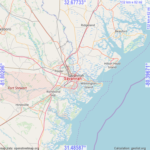
Savannah GPS coordinates[2]
32° 5' 0.744" North, 81° 5' 59.388" West
| Map corner | latitude | longitude |
|---|---|---|
| Upper-left | 32.67733°, | -81.80296° |
| Center: | 32.08354°, | -81.09983° |
| Lower-right: | 31.48587°, | -80.39671° |
| Map W x H: | 132.5×132.5 km | = 82.3×82.3mi |
| max Lat: | 71.29058° ⇑88.4% North |
| Savannah: | 32.08354° |
| min Lat: | ⇓11.6% South 19.06759° |
| min Long | Savannah | max Long |
| -171.73463° | -81.09983° | -66.98998° |
| W 69.2%⇐ | ⇒30.8% E |
Elevation
Elevation of Savannah is 9 m = 30 ft, and this is 285.8 m = 938 ft below average elevation for this country.
| Max E: |
3189 m = 10463 ft | 94.8% |
| Avg. | 294.8 m = 967 ft | |
| Savannah | 9 m = 30 ft | |
Min E: |
-60 m = -197 ft | 5.2% |
See also: Savannah elevation on elevation.city.
Geographical zone
Savannah is located in North temperate zone (between Tropic of Cancer and the Arctic Circle). Distance of this Northern Tropic circle is 961.4 km =597.4 mi to South.| Distance of | km | miles | from Savannah |
|---|---|---|---|
| North Pole | 6439.7 | 4001.4 | to North |
| Arctic Circle | 3833.8 | 2382.2 | to North |
| Tropic Cancer | 961.4 | 597.4 | to South |
| Equator | 3567.4 | 2216.7 | to South |


Nearby cities:
15 places around Savannah: (largest is in red/bold)
• Bloomingdale
19.5 km =12.1 mi,  286°
286°
• Garden City
6.1 km =3.8 mi,  303°
303°
• Georgetown
16.4 km =10.2 mi,  227°
227°
• Hardeeville
22.7 km =14.1 mi,  4°
4°
• Henderson
17.2 km =10.7 mi,  240°
240°
• Isle of Hope
11.9 km =7.4 mi,  162°
162°
• Montgomery
16 km =9.9 mi,  187°
187°
• Pooler
14.3 km =8.9 mi,  284°
284°
• Port Wentworth
9.4 km =5.8 mi,  320°
320°
• Richmond Hill
25.1 km =15.6 mi, 229°
• Skidaway Island
17.3 km =10.7 mi, 163°
• Thunderbolt
7.3 km =4.5 mi,  139°
139°
• Tybee Island
25.7 km =16 mi,  111°
111°
• Whitemarsh Island
9.9 km =6.2 mi,  127°
127°
• Wilmington Island
14.8 km =9.2 mi, 126°
Sources, notices
• [Note1] Compared only with cities in United States existing in our database
• [Src1] Map data: © OpenStreetMap contributors (CC-BY-SA)
• [Src2] Other city data from geonames.org with taken over terms of usage.
• [Src3] Geographical zone / Annual Mean Temperature by Robert A. Rohde @ Wikipedia
