Resaca geodata
Resaca (Georgia) is a populated place; located in United States in America/New_York (GMT-4) time zone. With population of 775 people, there are 18024 cities with bigger population in this country. Compared to other cities in United States, 77.3% of cities are located further ↑North; 56% of cities are located further ←West and 50.3% of cities have higher elevation than Resaca. Note1


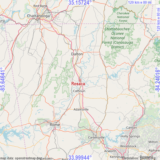
Resaca GPS coordinates[2]
34° 34' 49.296" North, 84° 56' 35.808" West
| Map corner | latitude | longitude |
|---|---|---|
| Upper-left | 35.15724°, | -85.64641° |
| Center: | 34.58036°, | -84.94328° |
| Lower-right: | 33.99944°, | -84.24016° |
| Map W x H: | 128.7×128.7 km | = 80×80mi |
| max Lat: | 71.29058° ⇑77.3% North |
| Resaca: | 34.58036° |
| min Lat: | ⇓22.7% South 19.06759° |
| min Long | Resaca | max Long |
| -171.73463° | -84.94328° | -66.98998° |
| W 56%⇐ | ⇒44% E |
Elevation
Elevation of Resaca is 197 m = 646 ft, and this is 97.8 m = 321 ft below average elevation for this country.
| Max E: |
3189 m = 10463 ft | 50.3% |
| Avg. | 294.8 m = 967 ft | |
| Resaca | 197 m = 646 ft | |
Min E: |
-60 m = -197 ft | 49.7% |
See also: United States elevation on elevation.city.
Geographical zone
Resaca is located in North temperate zone (between Tropic of Cancer and the Arctic Circle). Distance of this Northern Tropic circle is 1239.1 km =769.9 mi to South.| Distance of | km | miles | from Resaca |
|---|---|---|---|
| North Pole | 6162.1 | 3829 | to North |
| Arctic Circle | 3556.2 | 2209.7 | to North |
| Tropic Cancer | 1239.1 | 769.9 | to South |
| Equator | 3845 | 2389.2 | to South |


Nearby cities:
15 places around Resaca: (largest is in red/bold)
• Adairsville
23.5 km =14.6 mi,  177°
177°
• Calhoun
8.7 km =5.4 mi, 184°
• Chatsworth
26 km =16.2 mi,  37°
37°
• Dalton
21.2 km =13.2 mi,  353°
353°
• Eton
31.8 km =19.8 mi,  31°
31°
• Fairmount
27.5 km =17.1 mi,  125°
125°
• Kingston
38.2 km =23.7 mi, 180°
• LaFayette
33.9 km =21.1 mi,  294°
294°
• Rydal
34.3 km =21.3 mi,  142°
142°
• Shannon
29.5 km =18.3 mi,  203°
203°
• Summerville
38.7 km =24 mi,  253°
253°
• Trion
33.9 km =21.1 mi,  263°
263°
• Tunnel Hill
30.3 km =18.8 mi,  342°
342°
• Varnell
35.8 km =22.2 mi,  355°
355°
• White
37.7 km =23.4 mi,  151°
151°
Sources, notices
• [Note1] Compared only with cities in United States existing in our database
• [Src1] Map data: © OpenStreetMap contributors (CC-BY-SA)
• [Src2] Other city data from geonames.org with taken over terms of usage.
• [Src3] Geographical zone / Annual Mean Temperature by Robert A. Rohde @ Wikipedia
