Chatsworth geodata
Chatsworth (Georgia) is a seat of a second-order administrative division; located in United States in America/New_York (GMT-4) time zone. With population of 4,351 people, there are 7807 cities with bigger population in this country. Compared to other cities in United States, 76.5% of cities are located further ↑North; 56.4% of cities are located further ←West and 57.2% of cities have lower elevation than Chatsworth. Note1


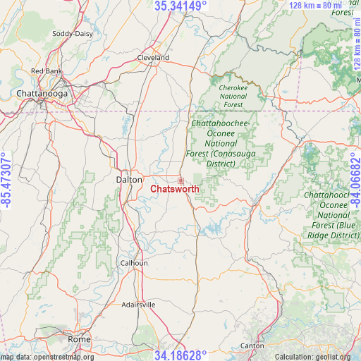
Chatsworth GPS coordinates[2]
34° 45' 57.276" North, 84° 46' 11.784" West
| Map corner | latitude | longitude |
|---|---|---|
| Upper-left | 35.34149°, | -85.47307° |
| Center: | 34.76591°, | -84.76994° |
| Lower-right: | 34.18628°, | -84.06682° |
| Map W x H: | 128.4×128.4 km | = 79.8×79.8mi |
| max Lat: | 71.29058° ⇑76.5% North |
| Chatsworth: | 34.76591° |
| min Lat: | ⇓23.5% South 19.06759° |
| min Long | Chatsworth | max Long |
| -171.73463° | -84.76994° | -66.98998° |
| W 56.4%⇐ | ⇒43.6% E |
Elevation
Elevation of Chatsworth is 227 m = 745 ft, and this is 67.8 m = 222 ft below average elevation for this country.
| Max E: |
3189 m = 10463 ft | 42.8% |
| Avg. | 294.8 m = 967 ft | |
| Chatsworth | 227 m = 745 ft | |
Min E: |
-60 m = -197 ft | 57.2% |
See also: United States elevation on elevation.city.
Geographical zone
Chatsworth is located in North temperate zone (between Tropic of Cancer and the Arctic Circle). Distance of this Northern Tropic circle is 1259.7 km =782.7 mi to South.| Distance of | km | miles | from Chatsworth |
|---|---|---|---|
| North Pole | 6141.5 | 3816.1 | to North |
| Arctic Circle | 3535.6 | 2196.9 | to North |
| Tropic Cancer | 1259.7 | 782.7 | to South |
| Equator | 3865.6 | 2402 | to South |


Nearby cities:
15 places around Chatsworth: (largest is in red/bold)
• Apison
36.9 km =22.9 mi,  321°
321°
• Calhoun
33.6 km =20.9 mi,  209°
209°
• Cohutta
27.2 km =16.9 mi, 322°
• Collegedale
40.9 km =25.4 mi, 321°
• Dalton
18.3 km =11.4 mi,  271°
271°
• East Ellijay
28.7 km =17.8 mi,  108°
108°
• Ellijay
27.5 km =17.1 mi, 106°
• Eton
6.6 km =4.1 mi,  5°
5°
• Fairmount
37.2 km =23.1 mi,  170°
170°
• Indian Springs
41.8 km =26 mi,  300°
300°
• Resaca
26 km =16.2 mi,  217°
217°
• Ringgold
35.2 km =21.9 mi, 298°
• Tunnel Hill
26.3 km =16.3 mi,  288°
288°
• Varnell
23.9 km =14.9 mi,  308°
308°
• Wildwood Lake
37.1 km =23.1 mi,  348°
348°
Sources, notices
• [Note1] Compared only with cities in United States existing in our database
• [Src1] Map data: © OpenStreetMap contributors (CC-BY-SA)
• [Src2] Other city data from geonames.org with taken over terms of usage.
• [Src3] Geographical zone / Annual Mean Temperature by Robert A. Rohde @ Wikipedia
