Waleska geodata
Waleska (Georgia) is a populated place; located in United States in America/New_York (GMT-4) time zone. With population of 802 people, there are 17797 cities with bigger population in this country. Compared to other cities in United States, 78.4% of cities are located further ↑North; 57.2% of cities are located further ←West and 79% of cities have lower elevation than Waleska. Note1


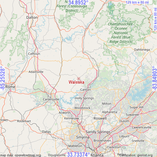
Waleska GPS coordinates[2]
34° 18' 59.328" North, 84° 33' 7.74" West
| Map corner | latitude | longitude |
|---|---|---|
| Upper-left | 34.8952°, | -85.25528° |
| Center: | 34.31648°, | -84.55215° |
| Lower-right: | 33.73374°, | -83.84903° |
| Map W x H: | 129.1×129.1 km | = 80.2×80.2mi |
| max Lat: | 71.29058° ⇑78.4% North |
| Waleska: | 34.31648° |
| min Lat: | ⇓21.6% South 19.06759° |
| min Long | Waleska | max Long |
| -171.73463° | -84.55215° | -66.98998° |
| W 57.2%⇐ | ⇒42.8% E |
Elevation
Elevation of Waleska is 344 m = 1129 ft, and this is 49.2 m = 161 ft above average elevation for this country.
| Max E: |
3189 m = 10463 ft | 21% |
| Waleska | 344 m 1129 ft | |
| Avg. | 294.8 m = 967 ft | |
Min E: |
-60 m = -197 ft | 79% |
See also: United States elevation on elevation.city.
Geographical zone
Waleska is located in North temperate zone (between Tropic of Cancer and the Arctic Circle). Distance of this Northern Tropic circle is 1209.7 km =751.7 mi to South.| Distance of | km | miles | from Waleska |
|---|---|---|---|
| North Pole | 6191.4 | 3847.2 | to North |
| Arctic Circle | 3585.5 | 2227.9 | to North |
| Tropic Cancer | 1209.7 | 751.7 | to South |
| Equator | 3815.6 | 2370.9 | to South |


Nearby cities:
15 places around Waleska: (largest is in red/bold)
• Acworth
30.1 km =18.7 mi,  202°
202°
• Ball Ground
16.3 km =10.1 mi,  81°
81°
• Canton
10.5 km =6.5 mi,  147°
147°
• Cartersville
28.5 km =17.7 mi,  233°
233°
• Emerson
28.2 km =17.5 mi,  221°
221°
• Fairmount
19 km =11.8 mi,  314°
314°
• Holly Springs
16.5 km =10.3 mi,  163°
163°
• Jasper
20.3 km =12.6 mi,  33°
33°
• Kennesaw
33.1 km =20.6 mi,  190°
190°
• Milton
30.9 km =19.2 mi,  131°
131°
• Mountain Park
29.2 km =18.1 mi, 153°
• Nelson
18.2 km =11.3 mi,  66°
66°
• Rydal
15.1 km =9.4 mi,  277°
277°
• White
18.1 km =11.2 mi,  258°
258°
• Woodstock
24.1 km =15 mi,  172°
172°
Sources, notices
• [Note1] Compared only with cities in United States existing in our database
• [Src1] Map data: © OpenStreetMap contributors (CC-BY-SA)
• [Src2] Other city data from geonames.org with taken over terms of usage.
• [Src3] Geographical zone / Annual Mean Temperature by Robert A. Rohde @ Wikipedia
