Cartersville geodata
Cartersville (Georgia) is a seat of a second-order administrative division; located in United States in America/New_York (GMT-4) time zone. With population of 20,319 people, there are 2473 cities with bigger population in this country. Compared to other cities in United States, 79.2% of cities are located further ↑North; 56.3% of cities are located further ←West and 59.4% of cities have lower elevation than Cartersville. Note1


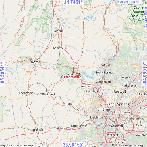
Cartersville GPS coordinates[2]
34° 9' 55.188" North, 84° 48' 8.316" West
| Map corner | latitude | longitude |
|---|---|---|
| Upper-left | 34.7451°, | -85.50544° |
| Center: | 34.16533°, | -84.80231° |
| Lower-right: | 33.58155°, | -84.09919° |
| Map W x H: | 129.4×129.4 km | = 80.4×80.4mi |
| max Lat: | 71.29058° ⇑79.2% North |
| Cartersville: | 34.16533° |
| min Lat: | ⇓20.8% South 19.06759° |
| min Long | Cartersville | max Long |
| -171.73463° | -84.80231° | -66.98998° |
| W 56.3%⇐ | ⇒43.7% E |
Elevation
Elevation of Cartersville is 237 m = 778 ft, and this is 57.8 m = 190 ft below average elevation for this country.
| Max E: |
3189 m = 10463 ft | 40.6% |
| Avg. | 294.8 m = 967 ft | |
| Cartersville | 237 m = 778 ft | |
Min E: |
-60 m = -197 ft | 59.4% |
See also: United States elevation on elevation.city.
Geographical zone
Cartersville is located in North temperate zone (between Tropic of Cancer and the Arctic Circle). Distance of this Northern Tropic circle is 1192.9 km =741.2 mi to South.| Distance of | km | miles | from Cartersville |
|---|---|---|---|
| North Pole | 6208.2 | 3857.6 | to North |
| Arctic Circle | 3602.3 | 2238.4 | to North |
| Tropic Cancer | 1192.9 | 741.2 | to South |
| Equator | 3798.8 | 2360.5 | to South |


Nearby cities:
15 places around Cartersville: (largest is in red/bold)
• Acworth
15.9 km =9.9 mi,  133°
133°
• Adairsville
25.7 km =16 mi,  331°
331°
• Aragon
26.9 km =16.7 mi,  240°
240°
• Canton
29.7 km =18.5 mi,  74°
74°
• Dallas
27.1 km =16.8 mi,  187°
187°
• Emerson
6.1 km =3.8 mi, 134°
• Euharlee
12.2 km =7.6 mi,  259°
259°
• Holly Springs
27.7 km =17.2 mi,  88°
88°
• Kennesaw
23.3 km =14.5 mi, 132°
• Kingston
15.3 km =9.5 mi,  301°
301°
• Rockmart
28.5 km =17.7 mi,  230°
230°
• Rydal
20.5 km =12.7 mi,  22°
22°
• Waleska
28.5 km =17.7 mi,  53°
53°
• White
14.1 km =8.8 mi, 21°
• Woodstock
27 km =16.8 mi,  105°
105°
Sources, notices
• [Note1] Compared only with cities in United States existing in our database
• [Src1] Map data: © OpenStreetMap contributors (CC-BY-SA)
• [Src2] Other city data from geonames.org with taken over terms of usage.
• [Src3] Geographical zone / Annual Mean Temperature by Robert A. Rohde @ Wikipedia
