Belleville geodata
Belleville (Illinois) is a seat of a second-order administrative division; located in United States in America/Chicago (GMT-5) time zone. With population of 42,034 people, there are 1139 cities with bigger population in this country. Compared to other cities in United States, 58.7% of cities are located further ↑North; 58.9% of cities are located further →East and 59.5% of cities have higher elevation than Belleville. Note1
Administrative division(s):
- Level 1: Illinois
- Level 2: Saint Clair County
- Level 3: Township of Belleville


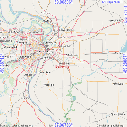
Belleville GPS coordinates[2]
38° 31' 12.18" North, 89° 59' 2.364" West
| Map corner | latitude | longitude |
|---|---|---|
| Upper-left | 39.06806°, | -90.68712° |
| Center: | 38.52005°, | -89.98399° |
| Lower-right: | 37.96783°, | -89.28087° |
| Map W x H: | 122.3×122.3 km | = 76×76mi |
| max Lat: | 71.29058° ⇑58.7% North |
| Belleville: | 38.52005° |
| min Lat: | ⇓41.3% South 19.06759° |
| min Long | Belleville | max Long |
| -171.73463° | -89.98399° | -66.98998° |
| W 41.1%⇐ | ⇒58.9% E |
Elevation
Elevation of Belleville is 157 m = 515 ft, and this is 137.8 m = 452 ft below average elevation for this country.
| Max E: |
3189 m = 10463 ft | 59.5% |
| Avg. | 294.8 m = 967 ft | |
| Belleville | 157 m = 515 ft | |
Min E: |
-60 m = -197 ft | 40.5% |
See also: Belleville elevation on elevation.city.
Geographical zone
Belleville is located in North temperate zone (between Tropic of Cancer and the Arctic Circle). Distance of this Northern Tropic circle is 1677.1 km =1042.1 mi to South.| Distance of | km | miles | from Belleville |
|---|---|---|---|
| North Pole | 5724 | 3556.7 | to North |
| Arctic Circle | 3118.1 | 1937.5 | to North |
| Tropic Cancer | 1677.1 | 1042.1 | to South |
| Equator | 4283 | 2661.3 | to South |


Nearby cities:
15 places around Belleville: (largest is in red/bold)
• Alorton
14.1 km =8.8 mi,  303°
303°
• Caseyville
13.5 km =8.4 mi,  344°
344°
• Centreville
14.1 km =8.8 mi, 299°
• Collinsville
16.7 km =10.4 mi,  359°
359°
• Fairmont City
17.3 km =10.7 mi,  326°
326°
• Fairview Heights
7.7 km =4.8 mi, 355°
• Freeburg
12 km =7.5 mi,  149°
149°
• Mascoutah
16.9 km =10.5 mi,  101°
101°
• Millstadt
11.4 km =7.1 mi,  235°
235°
• O'Fallon
10.2 km =6.3 mi,  38°
38°
• Scott Air Force Base
11.9 km =7.4 mi,  77°
77°
• Shiloh
8.8 km =5.5 mi,  58°
58°
• Smithton
12.4 km =7.7 mi,  183°
183°
• Swansea
1.6 km =1 mi, 344°
• Washington Park
15.9 km =9.9 mi,  323°
323°
Sources, notices
• [Note1] Compared only with cities in United States existing in our database
• [Src1] Map data: © OpenStreetMap contributors (CC-BY-SA)
• [Src2] Other city data from geonames.org with taken over terms of usage.
• [Src3] Geographical zone / Annual Mean Temperature by Robert A. Rohde @ Wikipedia
