Cahokia geodata
Cahokia (Illinois) is a populated place; located in United States in America/Chicago (GMT-5) time zone. With population of 14,402 people, there are 3358 cities with bigger population in this country. Compared to other cities in United States, 58.3% of cities are located further ↑North; 59.6% of cities are located further →East and 65.8% of cities have higher elevation than Cahokia. Note1
Administrative division(s):
- Level 1: Illinois
- Level 2: Saint Clair County
- Level 3: Township of Centreville


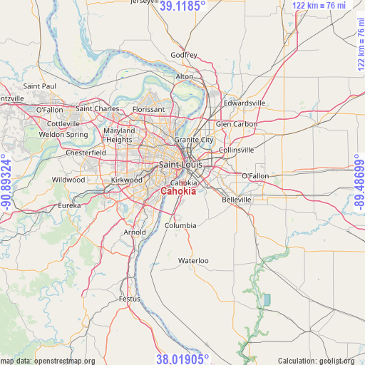
Cahokia GPS coordinates[2]
38° 34' 15.168" North, 90° 11' 24.396" West
| Map corner | latitude | longitude |
|---|---|---|
| Upper-left | 39.1185°, | -90.89324° |
| Center: | 38.57088°, | -90.19011° |
| Lower-right: | 38.01905°, | -89.48699° |
| Map W x H: | 122.2×122.2 km | = 75.9×75.9mi |
| max Lat: | 71.29058° ⇑58.3% North |
| Cahokia: | 38.57088° |
| min Lat: | ⇓41.7% South 19.06759° |
| min Long | Cahokia | max Long |
| -171.73463° | -90.19011° | -66.98998° |
| W 40.4%⇐ | ⇒59.6% E |
Elevation
Elevation of Cahokia is 124 m = 407 ft, and this is 170.8 m = 560 ft below average elevation for this country.
| Max E: |
3189 m = 10463 ft | 65.8% |
| Avg. | 294.8 m = 967 ft | |
| Cahokia | 124 m = 407 ft | |
Min E: |
-60 m = -197 ft | 34.2% |
See also: United States elevation on elevation.city.
Geographical zone
Cahokia is located in North temperate zone (between Tropic of Cancer and the Arctic Circle). Distance of this Northern Tropic circle is 1682.8 km =1045.6 mi to South.| Distance of | km | miles | from Cahokia |
|---|---|---|---|
| North Pole | 5718.4 | 3553.2 | to North |
| Arctic Circle | 3112.5 | 1934 | to North |
| Tropic Cancer | 1682.8 | 1045.6 | to South |
| Equator | 4288.7 | 2664.9 | to South |


Nearby cities:
15 places around Cahokia: (largest is in red/bold)
• Affton
12.6 km =7.8 mi,  259°
259°
• Alorton
6.4 km =4 mi,  70°
70°
• Bella Villa
8.5 km =5.3 mi,  247°
247°
• Benton
11.2 km =7 mi,  298°
298°
• Brooklyn
10 km =6.2 mi,  12°
12°
• Centreville
5.8 km =3.6 mi,  76°
76°
• Dupo
6.3 km =3.9 mi,  196°
196°
• East Saint Louis
6.9 km =4.3 mi,  29°
29°
• Fairmont City
12.2 km =7.6 mi,  43°
43°
• Lemay
8.8 km =5.5 mi,  241°
241°
• Maplewood
12.6 km =7.8 mi,  291°
291°
• Saint George
11.5 km =7.1 mi, 250°
• St. Louis
6.3 km =3.9 mi,  353°
353°
• Venice
11.4 km =7.1 mi, 8°
• Washington Park
11.1 km =6.9 mi,  49°
49°
Sources, notices
• [Note1] Compared only with cities in United States existing in our database
• [Src1] Map data: © OpenStreetMap contributors (CC-BY-SA)
• [Src2] Other city data from geonames.org with taken over terms of usage.
• [Src3] Geographical zone / Annual Mean Temperature by Robert A. Rohde @ Wikipedia
