Lemay geodata
Lemay (Missouri) is a populated place; located in United States in America/Chicago (GMT-5) time zone. With population of 16,645 people, there are 2949 cities with bigger population in this country. Compared to other cities in United States, 58.6% of cities are located further ↑North; 59.9% of cities are located further →East and 61.9% of cities have higher elevation than Lemay. Note1
Administrative division(s):
- Level 1: Missouri
- Level 2: Saint Louis County
- Level 3: Township of Lemay


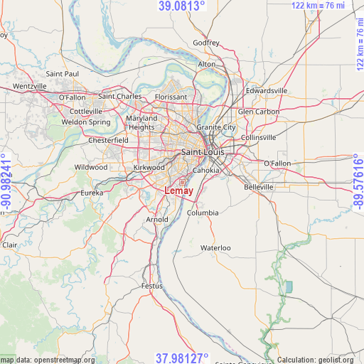
Lemay GPS coordinates[2]
38° 32' 0.204" North, 90° 16' 45.408" West
| Map corner | latitude | longitude |
|---|---|---|
| Upper-left | 39.0813°, | -90.98241° |
| Center: | 38.53339°, | -90.27928° |
| Lower-right: | 37.98127°, | -89.57616° |
| Map W x H: | 122.3×122.3 km | = 76×76mi |
| max Lat: | 71.29058° ⇑58.6% North |
| Lemay: | 38.53339° |
| min Lat: | ⇓41.4% South 19.06759° |
| min Long | Lemay | max Long |
| -171.73463° | -90.27928° | -66.98998° |
| W 40.1%⇐ | ⇒59.9% E |
Elevation
Elevation of Lemay is 145 m = 476 ft, and this is 149.8 m = 491 ft below average elevation for this country.
| Max E: |
3189 m = 10463 ft | 61.9% |
| Avg. | 294.8 m = 967 ft | |
| Lemay | 145 m = 476 ft | |
Min E: |
-60 m = -197 ft | 38.1% |
See also: United States elevation on elevation.city.
Geographical zone
Lemay is located in North temperate zone (between Tropic of Cancer and the Arctic Circle). Distance of this Northern Tropic circle is 1678.6 km =1043 mi to South.| Distance of | km | miles | from Lemay |
|---|---|---|---|
| North Pole | 5722.6 | 3555.9 | to North |
| Arctic Circle | 3116.7 | 1936.6 | to North |
| Tropic Cancer | 1678.6 | 1043 | to South |
| Equator | 4284.5 | 2662.3 | to South |


Nearby cities:
15 places around Lemay: (largest is in red/bold)
• Affton
5.1 km =3.2 mi,  292°
292°
• Bella Villa
0.9 km =0.6 mi,  355°
355°
• Cahokia
8.8 km =5.5 mi,  61°
61°
• Concord
6.9 km =4.3 mi,  261°
261°
• Crestwood
9.3 km =5.8 mi, 286°
• Dupo
6.3 km =3.9 mi,  107°
107°
• Grantwood Village
6.8 km =4.2 mi, 286°
• Green Park
5.3 km =3.3 mi, 258°
• Lakeshire
4.9 km =3 mi,  276°
276°
• Marlborough
6.5 km =4 mi,  309°
309°
• Mehlville
4.7 km =2.9 mi,  233°
233°
• Oakville
7.4 km =4.6 mi,  197°
197°
• Saint George
3.1 km =1.9 mi, 276°
• Sappington
8.8 km =5.5 mi,  272°
272°
• Shrewsbury
8.1 km =5 mi,  321°
321°
Sources, notices
• [Note1] Compared only with cities in United States existing in our database
• [Src1] Map data: © OpenStreetMap contributors (CC-BY-SA)
• [Src2] Other city data from geonames.org with taken over terms of usage.
• [Src3] Geographical zone / Annual Mean Temperature by Robert A. Rohde @ Wikipedia
