Hamel geodata
Hamel (Illinois) is a populated place; located in United States in America/Chicago (GMT-5) time zone. With population of 806 people, there are 17758 cities with bigger population in this country. Compared to other cities in United States, 55.9% of cities are located further ↑North; 58.6% of cities are located further →East and 58.2% of cities have higher elevation than Hamel. Note1


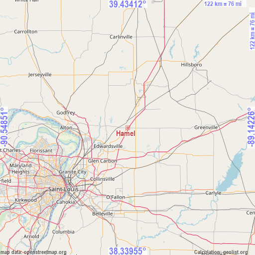
Hamel GPS coordinates[2]
38° 53' 20.184" North, 89° 50' 43.368" West
| Map corner | latitude | longitude |
|---|---|---|
| Upper-left | 39.43412°, | -90.54851° |
| Center: | 38.88894°, | -89.84538° |
| Lower-right: | 38.33955°, | -89.14226° |
| Map W x H: | 121.7×121.7 km | = 75.6×75.6mi |
| max Lat: | 71.29058° ⇑55.9% North |
| Hamel: | 38.88894° |
| min Lat: | ⇓44.1% South 19.06759° |
| min Long | Hamel | max Long |
| -171.73463° | -89.84538° | -66.98998° |
| W 41.4%⇐ | ⇒58.6% E |
Elevation
Elevation of Hamel is 164 m = 538 ft, and this is 130.8 m = 429 ft below average elevation for this country.
| Max E: |
3189 m = 10463 ft | 58.2% |
| Avg. | 294.8 m = 967 ft | |
| Hamel | 164 m = 538 ft | |
Min E: |
-60 m = -197 ft | 41.8% |
See also: United States elevation on elevation.city.
Geographical zone
Hamel is located in North temperate zone (between Tropic of Cancer and the Arctic Circle). Distance of this Northern Tropic circle is 1718.1 km =1067.6 mi to South.| Distance of | km | miles | from Hamel |
|---|---|---|---|
| North Pole | 5683 | 3531.3 | to North |
| Arctic Circle | 3077.1 | 1912 | to North |
| Tropic Cancer | 1718.1 | 1067.6 | to South |
| Equator | 4324 | 2686.8 | to South |


Nearby cities:
15 places around Hamel: (largest is in red/bold)
• Alhambra
9.9 km =6.2 mi,  90°
90°
• Bethalto
17 km =10.6 mi,  277°
277°
• Bunker Hill
19.4 km =12.1 mi,  331°
331°
• Edwardsville
12.7 km =7.9 mi,  227°
227°
• Glen Carbon
19.7 km =12.2 mi,  217°
217°
• Holiday Shores
9 km =5.6 mi,  294°
294°
• Livingston
11.2 km =7 mi,  38°
38°
• Marine
12.8 km =8 mi,  152°
152°
• Roxana
20.5 km =12.7 mi,  257°
257°
• Saint Jacob
20.6 km =12.8 mi,  161°
161°
• South Roxana
20 km =12.4 mi,  250°
250°
• Staunton
14.5 km =9 mi,  18°
18°
• Troy
18.1 km =11.2 mi,  190°
190°
• Wilsonville
20.3 km =12.6 mi,  357°
357°
• Worden
4.8 km =3 mi,  6°
6°
Sources, notices
• [Note1] Compared only with cities in United States existing in our database
• [Src1] Map data: © OpenStreetMap contributors (CC-BY-SA)
• [Src2] Other city data from geonames.org with taken over terms of usage.
• [Src3] Geographical zone / Annual Mean Temperature by Robert A. Rohde @ Wikipedia
