Troy geodata
Troy (Illinois) is a populated place; located in United States in America/Chicago (GMT-5) time zone. With population of 10,036 people, there are 4452 cities with bigger population in this country. Compared to other cities in United States, 57.2% of cities are located further ↑North; 58.7% of cities are located further →East and 57.1% of cities have higher elevation than Troy. Note1


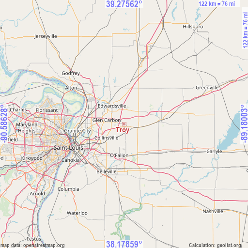
Troy GPS coordinates[2]
38° 43' 45.156" North, 89° 52' 59.34" West
| Map corner | latitude | longitude |
|---|---|---|
| Upper-left | 39.27562°, | -90.58628° |
| Center: | 38.72921°, | -89.88315° |
| Lower-right: | 38.17859°, | -89.18003° |
| Map W x H: | 122×122 km | = 75.8×75.8mi |
| max Lat: | 71.29058° ⇑57.2% North |
| Troy: | 38.72921° |
| min Lat: | ⇓42.8% South 19.06759° |
| min Long | Troy | max Long |
| -171.73463° | -89.88315° | -66.98998° |
| W 41.3%⇐ | ⇒58.7% E |
Elevation
Elevation of Troy is 170 m = 558 ft, and this is 124.8 m = 409 ft below average elevation for this country.
| Max E: |
3189 m = 10463 ft | 57.1% |
| Avg. | 294.8 m = 967 ft | |
| Troy | 170 m = 558 ft | |
Min E: |
-60 m = -197 ft | 42.9% |
See also: United States elevation on elevation.city.
Geographical zone
Troy is located in North temperate zone (between Tropic of Cancer and the Arctic Circle). Distance of this Northern Tropic circle is 1700.4 km =1056.6 mi to South.| Distance of | km | miles | from Troy |
|---|---|---|---|
| North Pole | 5700.8 | 3542.3 | to North |
| Arctic Circle | 3094.9 | 1923.1 | to North |
| Tropic Cancer | 1700.4 | 1056.6 | to South |
| Equator | 4306.3 | 2675.8 | to South |


Nearby cities:
15 places around Troy: (largest is in red/bold)
• Caseyville
16.1 km =10 mi,  230°
230°
• Collinsville
11 km =6.8 mi, 233°
• Edwardsville
11 km =6.8 mi,  326°
326°
• Fairview Heights
18.2 km =11.3 mi,  210°
210°
• Glen Carbon
8.9 km =5.5 mi,  283°
283°
• Hamel
18.1 km =11.2 mi,  10°
10°
• Highland
18.4 km =11.4 mi,  86°
86°
• Lebanon
15.4 km =9.6 mi,  154°
154°
• Marine
11.1 km =6.9 mi,  55°
55°
• Maryville
6.3 km =3.9 mi,  264°
264°
• Mitchell
17.9 km =11.1 mi, 281°
• O'Fallon
15.4 km =9.6 mi,  189°
189°
• Pontoon Beach
17.1 km =10.6 mi,  270°
270°
• Saint Jacob
10.1 km =6.3 mi,  99°
99°
• Shiloh
18.7 km =11.6 mi,  183°
183°
Sources, notices
• [Note1] Compared only with cities in United States existing in our database
• [Src1] Map data: © OpenStreetMap contributors (CC-BY-SA)
• [Src2] Other city data from geonames.org with taken over terms of usage.
• [Src3] Geographical zone / Annual Mean Temperature by Robert A. Rohde @ Wikipedia
