Red Bud geodata
Red Bud (Illinois) is a populated place; located in United States in America/Chicago (GMT-5) time zone. With population of 3,586 people, there are 8739 cities with bigger population in this country. Compared to other cities in United States, 60.6% of cities are located further ↑North; 59% of cities are located further →East and 62.2% of cities have higher elevation than Red Bud. Note1


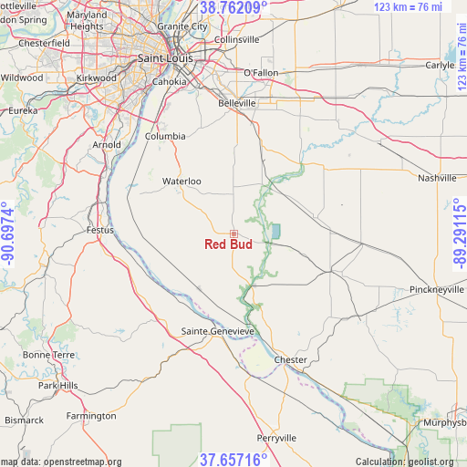
Red Bud GPS coordinates[2]
38° 12' 42.192" North, 89° 59' 39.372" West
| Map corner | latitude | longitude |
|---|---|---|
| Upper-left | 38.76209°, | -90.6974° |
| Center: | 38.21172°, | -89.99427° |
| Lower-right: | 37.65716°, | -89.29115° |
| Map W x H: | 122.9×122.9 km | = 76.4×76.4mi |
| max Lat: | 71.29058° ⇑60.6% North |
| Red Bud: | 38.21172° |
| min Lat: | ⇓39.4% South 19.06759° |
| min Long | Red Bud | max Long |
| -171.73463° | -89.99427° | -66.98998° |
| W 41%⇐ | ⇒59% E |
Elevation
Elevation of Red Bud is 143 m = 469 ft, and this is 151.8 m = 498 ft below average elevation for this country.
| Max E: |
3189 m = 10463 ft | 62.2% |
| Avg. | 294.8 m = 967 ft | |
| Red Bud | 143 m = 469 ft | |
Min E: |
-60 m = -197 ft | 37.8% |
See also: United States elevation on elevation.city.
Geographical zone
Red Bud is located in North temperate zone (between Tropic of Cancer and the Arctic Circle). Distance of this Northern Tropic circle is 1642.8 km =1020.8 mi to South.| Distance of | km | miles | from Red Bud |
|---|---|---|---|
| North Pole | 5758.3 | 3578 | to North |
| Arctic Circle | 3152.4 | 1958.8 | to North |
| Tropic Cancer | 1642.8 | 1020.8 | to South |
| Equator | 4248.7 | 2640 | to South |


Nearby cities:
15 places around Red Bud: (largest is in red/bold)
• Bloomsdale
29.8 km =18.5 mi,  221°
221°
• Columbia
31.5 km =19.6 mi,  325°
325°
• Evansville
14.4 km =8.9 mi,  160°
160°
• Freeburg
25 km =15.5 mi,  16°
16°
• Marissa
21.7 km =13.5 mi,  78°
78°
• Millstadt
29 km =18 mi,  342°
342°
• New Athens
16.4 km =10.2 mi,  38°
38°
• Prairie du Rocher
16.8 km =10.4 mi,  211°
211°
• Saint Libory
30 km =18.6 mi,  55°
55°
• Sainte Genevieve
25.9 km =16.1 mi,  189°
189°
• Smithton
21.9 km =13.6 mi,  0°
0°
• Sparta
27.4 km =17 mi,  111°
111°
• Tilden
27.2 km =16.9 mi,  89°
89°
• Valmeyer
26.8 km =16.7 mi,  292°
292°
• Waterloo
19.4 km =12.1 mi,  315°
315°
Sources, notices
• [Note1] Compared only with cities in United States existing in our database
• [Src1] Map data: © OpenStreetMap contributors (CC-BY-SA)
• [Src2] Other city data from geonames.org with taken over terms of usage.
• [Src3] Geographical zone / Annual Mean Temperature by Robert A. Rohde @ Wikipedia
