Shelbyville geodata
Shelbyville (Illinois) is a seat of a second-order administrative division; located in United States in America/Chicago (GMT-5) time zone. With population of 4,599 people, there are 7542 cities with bigger population in this country. Compared to other cities in United States, 51.5% of cities are located further ↑North; 55.6% of cities are located further →East and 50.5% of cities have lower elevation than Shelbyville. Note1
Administrative division(s):
- Level 1: Illinois
- Level 2: Shelby County
- Level 3: Township of Shelbyville


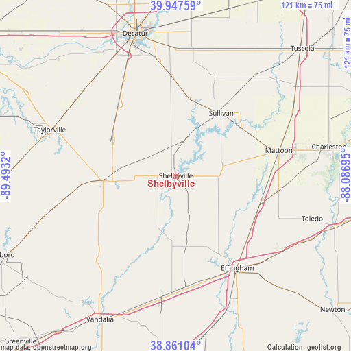
Shelbyville GPS coordinates[2]
39° 24' 23.148" North, 88° 47' 24.252" West
| Map corner | latitude | longitude |
|---|---|---|
| Upper-left | 39.94759°, | -89.4932° |
| Center: | 39.40643°, | -88.79007° |
| Lower-right: | 38.86104°, | -88.08695° |
| Map W x H: | 120.8×120.8 km | = 75.1×75.1mi |
| max Lat: | 71.29058° ⇑51.5% North |
| Shelbyville: | 39.40643° |
| min Lat: | ⇓48.5% South 19.06759° |
| min Long | Shelbyville | max Long |
| -171.73463° | -88.79007° | -66.98998° |
| W 44.4%⇐ | ⇒55.6% E |
Elevation
Elevation of Shelbyville is 200 m = 656 ft, and this is 94.8 m = 311 ft below average elevation for this country.
| Max E: |
3189 m = 10463 ft | 49.5% |
| Avg. | 294.8 m = 967 ft | |
| Shelbyville | 200 m = 656 ft | |
Min E: |
-60 m = -197 ft | 50.5% |
See also: United States elevation on elevation.city.
Geographical zone
Shelbyville is located in North temperate zone (between Tropic of Cancer and the Arctic Circle). Distance of this Northern Tropic circle is 1775.7 km =1103.4 mi to South.| Distance of | km | miles | from Shelbyville |
|---|---|---|---|
| North Pole | 5625.5 | 3495.5 | to North |
| Arctic Circle | 3019.6 | 1876.3 | to North |
| Tropic Cancer | 1775.7 | 1103.4 | to South |
| Equator | 4381.6 | 2722.6 | to South |


Nearby cities:
15 places around Shelbyville: (largest is in red/bold)
• Assumption
25.6 km =15.9 mi,  299°
299°
• Bethany
27 km =16.8 mi,  9°
9°
• Cowden
18.6 km =11.6 mi,  199°
199°
• Dalton City
34 km =21.1 mi,  357°
357°
• Effingham
38.3 km =23.8 mi,  146°
146°
• Findlay
13.3 km =8.3 mi, 13°
• Lovington
36.9 km =22.9 mi,  21°
21°
• Mattoon
36.8 km =22.9 mi,  76°
76°
• Moweaqua
31.2 km =19.4 mi,  321°
321°
• Neoga
30.6 km =19 mi,  108°
108°
• Pana
25 km =15.5 mi,  265°
265°
• Stewardson
21.1 km =13.1 mi,  139°
139°
• Sullivan
26.6 km =16.5 mi,  36°
36°
• Tower Hill
14.8 km =9.2 mi,  261°
261°
• Windsor
17.2 km =10.7 mi, 77°
Sources, notices
• [Note1] Compared only with cities in United States existing in our database
• [Src1] Map data: © OpenStreetMap contributors (CC-BY-SA)
• [Src2] Other city data from geonames.org with taken over terms of usage.
• [Src3] Geographical zone / Annual Mean Temperature by Robert A. Rohde @ Wikipedia
