Warrensburg geodata
Warrensburg (Illinois) is a populated place; located in United States in America/Chicago (GMT-5) time zone. With population of 1,163 people, there are 15318 cities with bigger population in this country. Compared to other cities in United States, 52.8% of cities are located further ↓South; 56.3% of cities are located further →East and 54.7% of cities have lower elevation than Warrensburg. Note1


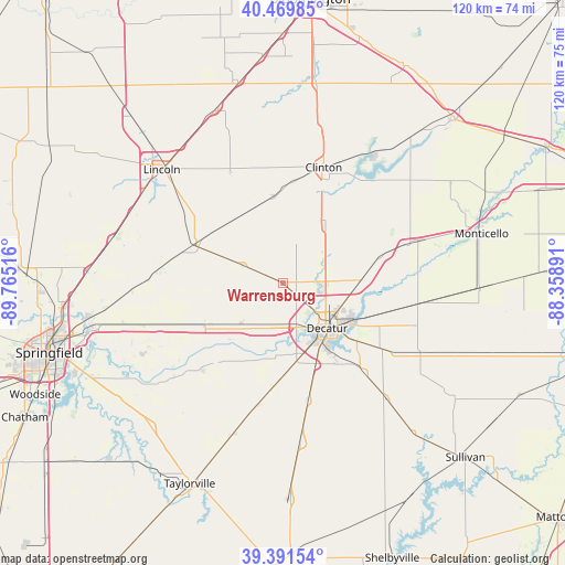
Warrensburg GPS coordinates[2]
39° 55' 58.152" North, 89° 3' 43.308" West
| Map corner | latitude | longitude |
|---|---|---|
| Upper-left | 40.46985°, | -89.76516° |
| Center: | 39.93282°, | -89.06203° |
| Lower-right: | 39.39154°, | -88.35891° |
| Map W x H: | 119.9×119.9 km | = 74.5×74.5mi |
| max Lat: | 71.29058° ⇑47.2% North |
| Warrensburg: | 39.93282° |
| min Lat: | ⇓52.8% South 19.06759° |
| min Long | Warrensburg | max Long |
| -171.73463° | -89.06203° | -66.98998° |
| W 43.7%⇐ | ⇒56.3% E |
Elevation
Elevation of Warrensburg is 217 m = 712 ft, and this is 77.8 m = 255 ft below average elevation for this country.
| Max E: |
3189 m = 10463 ft | 45.3% |
| Avg. | 294.8 m = 967 ft | |
| Warrensburg | 217 m = 712 ft | |
Min E: |
-60 m = -197 ft | 54.7% |
See also: United States elevation on elevation.city.
Geographical zone
Warrensburg is located in North temperate zone (between Tropic of Cancer and the Arctic Circle). Distance of this Northern Tropic circle is 1834.2 km =1139.7 mi to South.| Distance of | km | miles | from Warrensburg |
|---|---|---|---|
| North Pole | 5566.9 | 3459.1 | to North |
| Arctic Circle | 2961.1 | 1839.9 | to North |
| Tropic Cancer | 1834.2 | 1139.7 | to South |
| Equator | 4440.1 | 2758.9 | to South |


Nearby cities:
15 places around Warrensburg: (largest is in red/bold)
• Argenta
21.1 km =13.1 mi,  74°
74°
• Blue Mound
26.3 km =16.3 mi,  191°
191°
• Chapin
25.2 km =15.7 mi,  103°
103°
• Clinton
25.9 km =16.1 mi,  18°
18°
• Decatur
13.8 km =8.6 mi,  138°
138°
• Forsyth
9.5 km =5.9 mi,  90°
90°
• Harristown
9 km =5.6 mi, 192°
• Illiopolis
17.7 km =11 mi,  240°
240°
• Long Creek
22.7 km =14.1 mi,  126°
126°
• Macon
25.1 km =15.6 mi,  167°
167°
• Maroa
14.6 km =9.1 mi,  37°
37°
• Mount Pulaski
20.7 km =12.9 mi,  294°
294°
• Mount Zion
24.1 km =15 mi, 138°
• Niantic
12.5 km =7.8 mi,  225°
225°
• Oreana
16.8 km =10.4 mi, 87°
Sources, notices
• [Note1] Compared only with cities in United States existing in our database
• [Src1] Map data: © OpenStreetMap contributors (CC-BY-SA)
• [Src2] Other city data from geonames.org with taken over terms of usage.
• [Src3] Geographical zone / Annual Mean Temperature by Robert A. Rohde @ Wikipedia
