Niantic geodata
Niantic (Illinois) is a populated place; located in United States in America/Chicago (GMT-5) time zone. With population of 673 people, there are 18941 cities with bigger population in this country. Compared to other cities in United States, 52% of cities are located further ↓South; 56.6% of cities are located further →East and 53.1% of cities have higher elevation than Niantic. Note1


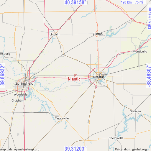
Niantic GPS coordinates[2]
39° 51' 14.148" North, 89° 9' 58.284" West
| Map corner | latitude | longitude |
|---|---|---|
| Upper-left | 40.39158°, | -89.86932° |
| Center: | 39.85393°, | -89.16619° |
| Lower-right: | 39.31203°, | -88.46307° |
| Map W x H: | 120×120 km | = 74.6×74.6mi |
| max Lat: | 71.29058° ⇑48% North |
| Niantic: | 39.85393° |
| min Lat: | ⇓52% South 19.06759° |
| min Long | Niantic | max Long |
| -171.73463° | -89.16619° | -66.98998° |
| W 43.4%⇐ | ⇒56.6% E |
Elevation
Elevation of Niantic is 187 m = 614 ft, and this is 107.8 m = 354 ft below average elevation for this country.
| Max E: |
3189 m = 10463 ft | 53.1% |
| Avg. | 294.8 m = 967 ft | |
| Niantic | 187 m = 614 ft | |
Min E: |
-60 m = -197 ft | 46.9% |
See also: United States elevation on elevation.city.
Geographical zone
Niantic is located in North temperate zone (between Tropic of Cancer and the Arctic Circle). Distance of this Northern Tropic circle is 1825.4 km =1134.3 mi to South.| Distance of | km | miles | from Niantic |
|---|---|---|---|
| North Pole | 5575.7 | 3464.6 | to North |
| Arctic Circle | 2969.8 | 1845.3 | to North |
| Tropic Cancer | 1825.4 | 1134.3 | to South |
| Equator | 4431.3 | 2753.5 | to South |


Nearby cities:
15 places around Niantic: (largest is in red/bold)
• Blue Mound
17.4 km =10.8 mi,  167°
167°
• Decatur
18.1 km =11.2 mi,  94°
94°
• Forsyth
20.3 km =12.6 mi,  64°
64°
• Harristown
7 km =4.3 mi, 90°
• Illiopolis
6.5 km =4 mi,  269°
269°
• Long Creek
27.6 km =17.1 mi,  99°
99°
• Macon
21.3 km =13.2 mi,  137°
137°
• Maroa
27 km =16.8 mi,  41°
41°
• Mechanicsburg
20.3 km =12.6 mi,  255°
255°
• Mount Pulaski
20.1 km =12.5 mi,  330°
330°
• Mount Zion
26.6 km =16.5 mi,  110°
110°
• Moweaqua
28.4 km =17.6 mi,  153°
153°
• Oreana
27.3 km =17 mi,  69°
69°
• Stonington
23.9 km =14.9 mi,  185°
185°
• Warrensburg
12.5 km =7.8 mi,  45°
45°
Sources, notices
• [Note1] Compared only with cities in United States existing in our database
• [Src1] Map data: © OpenStreetMap contributors (CC-BY-SA)
• [Src2] Other city data from geonames.org with taken over terms of usage.
• [Src3] Geographical zone / Annual Mean Temperature by Robert A. Rohde @ Wikipedia
