Winchester geodata
Winchester (Illinois) is a seat of a second-order administrative division; located in United States in America/Chicago (GMT-5) time zone. With population of 1,513 people, there are 13609 cities with bigger population in this country. Compared to other cities in United States, 50.1% of cities are located further ↓South; 60.7% of cities are located further →East and 57.5% of cities have higher elevation than Winchester. Note1


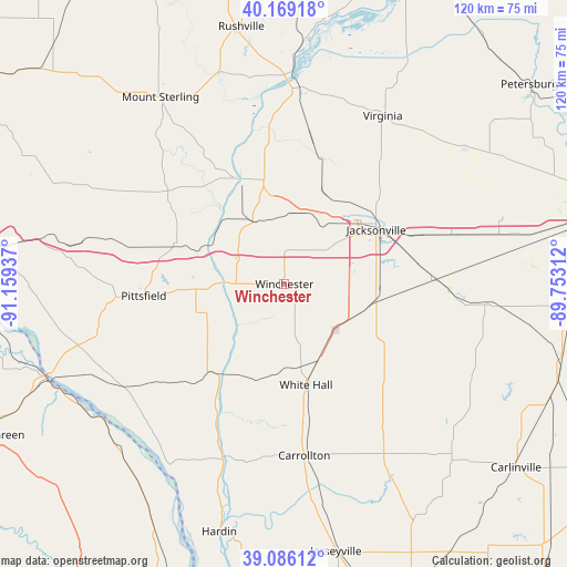
Winchester GPS coordinates[2]
39° 37' 47.172" North, 90° 27' 22.464" West
| Map corner | latitude | longitude |
|---|---|---|
| Upper-left | 40.16918°, | -91.15937° |
| Center: | 39.62977°, | -90.45624° |
| Lower-right: | 39.08612°, | -89.75312° |
| Map W x H: | 120.4×120.4 km | = 74.8×74.8mi |
| max Lat: | 71.29058° ⇑49.9% North |
| Winchester: | 39.62977° |
| min Lat: | ⇓50.1% South 19.06759° |
| min Long | Winchester | max Long |
| -171.73463° | -90.45624° | -66.98998° |
| W 39.3%⇐ | ⇒60.7% E |
Elevation
Elevation of Winchester is 168 m = 551 ft, and this is 126.8 m = 416 ft below average elevation for this country.
| Max E: |
3189 m = 10463 ft | 57.5% |
| Avg. | 294.8 m = 967 ft | |
| Winchester | 168 m = 551 ft | |
Min E: |
-60 m = -197 ft | 42.5% |
See also: United States elevation on elevation.city.
Geographical zone
Winchester is located in North temperate zone (between Tropic of Cancer and the Arctic Circle). Distance of this Northern Tropic circle is 1800.5 km =1118.8 mi to South.| Distance of | km | miles | from Winchester |
|---|---|---|---|
| North Pole | 5600.6 | 3480.1 | to North |
| Arctic Circle | 2994.8 | 1860.9 | to North |
| Tropic Cancer | 1800.5 | 1118.8 | to South |
| Equator | 4406.4 | 2738 | to South |


Nearby cities:
15 places around Winchester: (largest is in red/bold)
• Bluffs
15.2 km =9.4 mi,  333°
333°
• Carrollton
36.7 km =22.8 mi,  173°
173°
• Franklin
35.3 km =21.9 mi,  91°
91°
• Greenfield
38.1 km =23.7 mi,  146°
146°
• Griggsville
24.6 km =15.3 mi,  290°
290°
• Jacksonville
22.6 km =14 mi,  59°
59°
• Meredosia
24.1 km =15 mi,  338°
338°
• Murrayville
18.2 km =11.3 mi,  105°
105°
• Pittsfield
30 km =18.6 mi,  265°
265°
• Pleasant Hill
41.3 km =25.7 mi,  239°
239°
• Roodhouse
17.8 km =11.1 mi,  155°
155°
• South Jacksonville
21.4 km =13.3 mi,  65°
65°
• Virginia
41.4 km =25.7 mi,  30°
30°
• White Hall
21.9 km =13.6 mi, 168°
• Woodson
20.3 km =12.6 mi, 90°
Sources, notices
• [Note1] Compared only with cities in United States existing in our database
• [Src1] Map data: © OpenStreetMap contributors (CC-BY-SA)
• [Src2] Other city data from geonames.org with taken over terms of usage.
• [Src3] Geographical zone / Annual Mean Temperature by Robert A. Rohde @ Wikipedia
