Jasonville geodata
Jasonville (Indiana) is a populated place; located in United States in America/Indiana/Indianapolis (GMT-4) time zone. With population of 2,165 people, there are 11427 cities with bigger population in this country. Compared to other cities in United States, 53.3% of cities are located further ↑North; 50.1% of cities are located further →East and 51.6% of cities have higher elevation than Jasonville. Note1


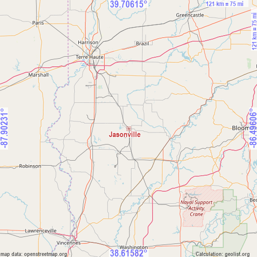
Jasonville GPS coordinates[2]
39° 9' 47.16" North, 87° 11' 57.048" West
| Map corner | latitude | longitude |
|---|---|---|
| Upper-left | 39.70615°, | -87.90231° |
| Center: | 39.1631°, | -87.19918° |
| Lower-right: | 38.61582°, | -86.49606° |
| Map W x H: | 121.2×121.2 km | = 75.3×75.3mi |
| max Lat: | 71.29058° ⇑53.3% North |
| Jasonville: | 39.1631° |
| min Lat: | ⇓46.7% South 19.06759° |
| min Long | Jasonville | max Long |
| -171.73463° | -87.19918° | -66.98998° |
| W 49.9%⇐ | ⇒50.1% E |
Elevation
Elevation of Jasonville is 192 m = 630 ft, and this is 102.8 m = 337 ft below average elevation for this country.
| Max E: |
3189 m = 10463 ft | 51.6% |
| Avg. | 294.8 m = 967 ft | |
| Jasonville | 192 m = 630 ft | |
Min E: |
-60 m = -197 ft | 48.4% |
See also: United States elevation on elevation.city.
Geographical zone
Jasonville is located in North temperate zone (between Tropic of Cancer and the Arctic Circle). Distance of this Northern Tropic circle is 1748.6 km =1086.5 mi to South.| Distance of | km | miles | from Jasonville |
|---|---|---|---|
| North Pole | 5652.5 | 3512.3 | to North |
| Arctic Circle | 3046.6 | 1893.1 | to North |
| Tropic Cancer | 1748.6 | 1086.5 | to South |
| Equator | 4354.5 | 2705.8 | to South |


Nearby cities:
15 places around Jasonville: (largest is in red/bold)
• Bloomfield
27.2 km =16.9 mi,  123°
123°
• Carlisle
28 km =17.4 mi,  219°
219°
• Clay City
14.7 km =9.1 mi,  30°
30°
• Dugger
11.7 km =7.3 mi,  207°
207°
• Elnora
33.1 km =20.6 mi,  162°
162°
• Farmersburg
18.4 km =11.4 mi,  301°
301°
• Freelandville
34.4 km =21.4 mi,  195°
195°
• Greenville
9.2 km =5.7 mi,  254°
254°
• Hymera
9.2 km =5.7 mi,  286°
286°
• Linton
14.6 km =9.1 mi,  168°
168°
• Lyons
21.8 km =13.5 mi,  152°
152°
• Middlebury
13.2 km =8.2 mi, 31°
• Shelburn
16.8 km =10.4 mi,  275°
275°
• Sullivan
19.4 km =12.1 mi, 247°
• Worthington
19.4 km =12.1 mi,  102°
102°
Sources, notices
• [Note1] Compared only with cities in United States existing in our database
• [Src1] Map data: © OpenStreetMap contributors (CC-BY-SA)
• [Src2] Other city data from geonames.org with taken over terms of usage.
• [Src3] Geographical zone / Annual Mean Temperature by Robert A. Rohde @ Wikipedia
