Farmersburg geodata
Farmersburg (Indiana) is a populated place; located in United States in America/Indiana/Indianapolis (GMT-4) time zone. With population of 1,094 people, there are 15708 cities with bigger population in this country. Compared to other cities in United States, 52.6% of cities are located further ↑North; 50.5% of cities are located further →East and 56.9% of cities have higher elevation than Farmersburg. Note1


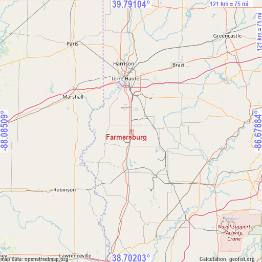
Farmersburg GPS coordinates[2]
39° 14' 55.14" North, 87° 22' 55.056" West
| Map corner | latitude | longitude |
|---|---|---|
| Upper-left | 39.79104°, | -88.08509° |
| Center: | 39.24865°, | -87.38196° |
| Lower-right: | 38.70203°, | -86.67884° |
| Map W x H: | 121.1×121.1 km | = 75.2×75.2mi |
| max Lat: | 71.29058° ⇑52.6% North |
| Farmersburg: | 39.24865° |
| min Lat: | ⇓47.4% South 19.06759° |
| min Long | Farmersburg | max Long |
| -171.73463° | -87.38196° | -66.98998° |
| W 49.5%⇐ | ⇒50.5% E |
Elevation
Elevation of Farmersburg is 171 m = 561 ft, and this is 123.8 m = 406 ft below average elevation for this country.
| Max E: |
3189 m = 10463 ft | 56.9% |
| Avg. | 294.8 m = 967 ft | |
| Farmersburg | 171 m = 561 ft | |
Min E: |
-60 m = -197 ft | 43.1% |
See also: United States elevation on elevation.city.
Geographical zone
Farmersburg is located in North temperate zone (between Tropic of Cancer and the Arctic Circle). Distance of this Northern Tropic circle is 1758.1 km =1092.4 mi to South.| Distance of | km | miles | from Farmersburg |
|---|---|---|---|
| North Pole | 5643 | 3506.4 | to North |
| Arctic Circle | 3037.1 | 1887.2 | to North |
| Tropic Cancer | 1758.1 | 1092.4 | to South |
| Equator | 4364 | 2711.7 | to South |


Nearby cities:
15 places around Farmersburg: (largest is in red/bold)
• Clay City
23.4 km =14.5 mi,  82°
82°
• Dugger
22.4 km =13.9 mi,  152°
152°
• Greenville
13.8 km =8.6 mi, 150°
• Hutsonville
28.3 km =17.6 mi,  236°
236°
• Hymera
9.8 km =6.1 mi,  135°
135°
• Jasonville
18.4 km =11.4 mi,  121°
121°
• Linton
30.2 km =18.8 mi, 141°
• Middlebury
22.7 km =14.1 mi,  85°
85°
• North Terre Haute
31.1 km =19.3 mi,  3°
3°
• Saint Mary-of-the-Woods
30.1 km =18.7 mi,  345°
345°
• Seelyville
28.8 km =17.9 mi,  20°
20°
• Shelburn
7.9 km =4.9 mi,  187°
187°
• Sullivan
17.2 km =10.7 mi, 186°
• Terre Haute
24.4 km =15.2 mi, 353°
• West Terre Haute
24.8 km =15.4 mi, 346°
Sources, notices
• [Note1] Compared only with cities in United States existing in our database
• [Src1] Map data: © OpenStreetMap contributors (CC-BY-SA)
• [Src2] Other city data from geonames.org with taken over terms of usage.
• [Src3] Geographical zone / Annual Mean Temperature by Robert A. Rohde @ Wikipedia
