Knightsville geodata
Knightsville (Indiana) is a populated place; located in United States in America/Indiana/Indianapolis (GMT-4) time zone. With population of 872 people, there are 17174 cities with bigger population in this country. Compared to other cities in United States, 50.7% of cities are located further ↑North; 50% of cities are located further ←West and 51.9% of cities have lower elevation than Knightsville. Note1


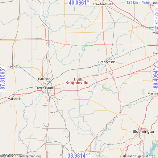
Knightsville GPS coordinates[2]
39° 31' 33.132" North, 87° 6' 45.072" West
| Map corner | latitude | longitude |
|---|---|---|
| Upper-left | 40.0661°, | -87.81565° |
| Center: | 39.52587°, | -87.11252° |
| Lower-right: | 38.98141°, | -86.4094° |
| Map W x H: | 120.6×120.6 km | = 74.9×74.9mi |
| max Lat: | 71.29058° ⇑50.7% North |
| Knightsville: | 39.52587° |
| min Lat: | ⇓49.3% South 19.06759° |
| min Long | Knightsville | max Long |
| -171.73463° | -87.11252° | -66.98998° |
| W 50%⇐ | ⇒50% E |
Elevation
Elevation of Knightsville is 206 m = 676 ft, and this is 88.8 m = 291 ft below average elevation for this country.
| Max E: |
3189 m = 10463 ft | 48.1% |
| Avg. | 294.8 m = 967 ft | |
| Knightsville | 206 m = 676 ft | |
Min E: |
-60 m = -197 ft | 51.9% |
See also: United States elevation on elevation.city.
Geographical zone
Knightsville is located in North temperate zone (between Tropic of Cancer and the Arctic Circle). Distance of this Northern Tropic circle is 1788.9 km =1111.6 mi to South.| Distance of | km | miles | from Knightsville |
|---|---|---|---|
| North Pole | 5612.2 | 3487.3 | to North |
| Arctic Circle | 3006.3 | 1868 | to North |
| Tropic Cancer | 1788.9 | 1111.6 | to South |
| Equator | 4394.9 | 2730.9 | to South |


Nearby cities:
15 places around Knightsville: (largest is in red/bold)
• Brazil
1.1 km =0.7 mi,  257°
257°
• Clay City
27.7 km =17.2 mi,  180°
180°
• Clinton
28.5 km =17.7 mi,  300°
300°
• Cloverdale
27.4 km =17 mi,  92°
92°
• Greencastle
25 km =15.5 mi,  58°
58°
• Harmony
1.3 km =0.8 mi,  25°
25°
• Middlebury
29.1 km =18.1 mi, 181°
• North Terre Haute
21.3 km =13.2 mi,  270°
270°
• Rockville
28.1 km =17.5 mi,  339°
339°
• Rosedale
18.2 km =11.3 mi,  306°
306°
• Seelyville
13.8 km =8.6 mi,  254°
254°
• Staunton
7.8 km =4.8 mi,  236°
236°
• Tecumseh
26.8 km =16.7 mi,  278°
278°
• Terre Haute
26.7 km =16.6 mi, 255°
• West Terre Haute
29.7 km =18.5 mi, 256°
Sources, notices
• [Note1] Compared only with cities in United States existing in our database
• [Src1] Map data: © OpenStreetMap contributors (CC-BY-SA)
• [Src2] Other city data from geonames.org with taken over terms of usage.
• [Src3] Geographical zone / Annual Mean Temperature by Robert A. Rohde @ Wikipedia
