New Market geodata
New Market (Indiana) is a populated place; located in United States in America/Indiana/Indianapolis (GMT-4) time zone. With population of 630 people, there are 19355 cities with bigger population in this country. Compared to other cities in United States, 53.1% of cities are located further ↓South; 50.4% of cities are located further ←West and 62.1% of cities have lower elevation than New Market. Note1


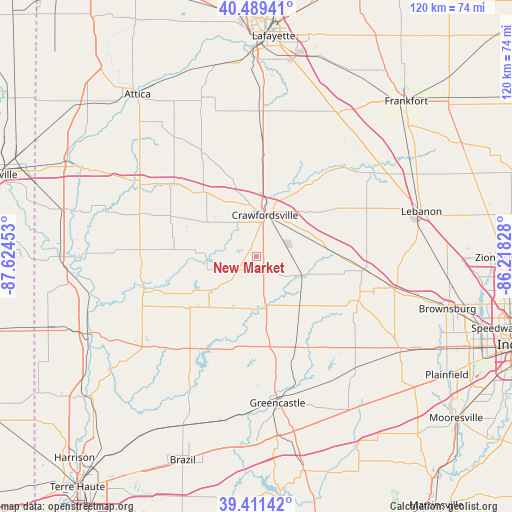
New Market GPS coordinates[2]
39° 57' 9.144" North, 86° 55' 17.04" West
| Map corner | latitude | longitude |
|---|---|---|
| Upper-left | 40.48941°, | -87.62453° |
| Center: | 39.95254°, | -86.9214° |
| Lower-right: | 39.41142°, | -86.21828° |
| Map W x H: | 119.9×119.9 km | = 74.5×74.5mi |
| max Lat: | 71.29058° ⇑46.9% North |
| New Market: | 39.95254° |
| min Lat: | ⇓53.1% South 19.06759° |
| min Long | New Market | max Long |
| -171.73463° | -86.9214° | -66.98998° |
| W 50.4%⇐ | ⇒49.6% E |
Elevation
Elevation of New Market is 249 m = 817 ft, and this is 45.8 m = 150 ft below average elevation for this country.
| Max E: |
3189 m = 10463 ft | 37.9% |
| Avg. | 294.8 m = 967 ft | |
| New Market | 249 m = 817 ft | |
Min E: |
-60 m = -197 ft | 62.1% |
See also: United States elevation on elevation.city.
Geographical zone
New Market is located in North temperate zone (between Tropic of Cancer and the Arctic Circle). Distance of this Northern Tropic circle is 1836.4 km =1141.1 mi to South.| Distance of | km | miles | from New Market |
|---|---|---|---|
| North Pole | 5564.8 | 3457.8 | to North |
| Arctic Circle | 2958.9 | 1838.6 | to North |
| Tropic Cancer | 1836.4 | 1141.1 | to South |
| Equator | 4442.3 | 2760.3 | to South |


Nearby cities:
15 places around New Market: (largest is in red/bold)
• Advance
26.1 km =16.2 mi,  79°
79°
• Bainbridge
23.2 km =14.4 mi,  156°
156°
• Crawfordsville
10.6 km =6.6 mi,  22°
22°
• Darlington
21.6 km =13.4 mi,  36°
36°
• Heritage Lake
30.8 km =19.1 mi,  144°
144°
• Hillsboro
28.4 km =17.6 mi,  307°
307°
• Jamestown
25.1 km =15.6 mi,  96°
96°
• Ladoga
11.1 km =6.9 mi,  112°
112°
• Lake Holiday
4.2 km =2.6 mi,  292°
292°
• Linden
26.2 km =16.3 mi,  3°
3°
• North Salem
25.9 km =16.1 mi, 113°
• Roachdale
15.4 km =9.6 mi, 138°
• Rockport
31.5 km =19.6 mi,  255°
255°
• Thorntown
33.2 km =20.6 mi,  53°
53°
• Waynetown
19.1 km =11.9 mi,  321°
321°
Sources, notices
• [Note1] Compared only with cities in United States existing in our database
• [Src1] Map data: © OpenStreetMap contributors (CC-BY-SA)
• [Src2] Other city data from geonames.org with taken over terms of usage.
• [Src3] Geographical zone / Annual Mean Temperature by Robert A. Rohde @ Wikipedia
