Waynetown geodata
Waynetown (Indiana) is a populated place; located in United States in America/Indiana/Indianapolis (GMT-4) time zone. With population of 956 people, there are 16596 cities with bigger population in this country. Compared to other cities in United States, 54.4% of cities are located further ↓South; 50.1% of cities are located further ←West and 59.1% of cities have lower elevation than Waynetown. Note1


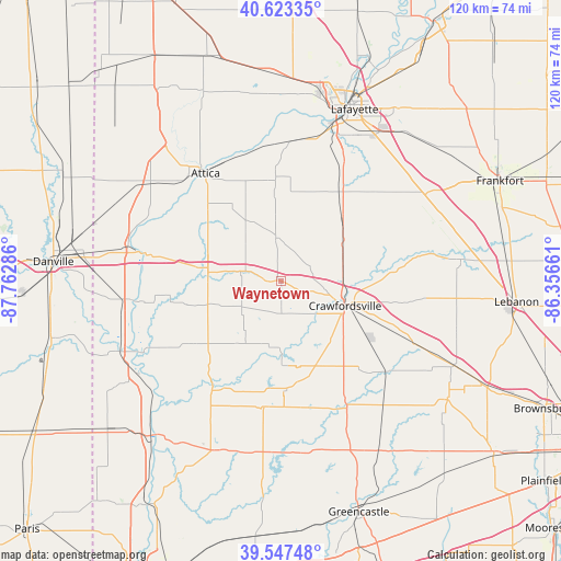
Waynetown GPS coordinates[2]
40° 5' 15.144" North, 87° 3' 35.028" West
| Map corner | latitude | longitude |
|---|---|---|
| Upper-left | 40.62335°, | -87.76286° |
| Center: | 40.08754°, | -87.05973° |
| Lower-right: | 39.54748°, | -86.35661° |
| Map W x H: | 119.6×119.6 km | = 74.3×74.3mi |
| max Lat: | 71.29058° ⇑45.6% North |
| Waynetown: | 40.08754° |
| min Lat: | ⇓54.4% South 19.06759° |
| min Long | Waynetown | max Long |
| -171.73463° | -87.05973° | -66.98998° |
| W 50.1%⇐ | ⇒49.9% E |
Elevation
Elevation of Waynetown is 236 m = 774 ft, and this is 58.8 m = 193 ft below average elevation for this country.
| Max E: |
3189 m = 10463 ft | 40.9% |
| Avg. | 294.8 m = 967 ft | |
| Waynetown | 236 m = 774 ft | |
Min E: |
-60 m = -197 ft | 59.1% |
See also: United States elevation on elevation.city.
Geographical zone
Waynetown is located in North temperate zone (between Tropic of Cancer and the Arctic Circle). Distance of this Northern Tropic circle is 1851.4 km =1150.4 mi to South.| Distance of | km | miles | from Waynetown |
|---|---|---|---|
| North Pole | 5549.7 | 3448.4 | to North |
| Arctic Circle | 2943.9 | 1829.3 | to North |
| Tropic Cancer | 1851.4 | 1150.4 | to South |
| Equator | 4457.3 | 2769.6 | to South |


Nearby cities:
15 places around Waynetown: (largest is in red/bold)
• Attica
28 km =17.4 mi,  325°
325°
• Covington
29.1 km =18.1 mi,  281°
281°
• Crawfordsville
16.6 km =10.3 mi,  108°
108°
• Darlington
24.6 km =15.3 mi,  84°
84°
• Hillsboro
11 km =6.8 mi, 282°
• Ladoga
29.3 km =18.2 mi,  131°
131°
• Lake Holiday
15.5 km =9.6 mi,  149°
149°
• Linden
17.3 km =10.7 mi,  49°
49°
• New Market
19.1 km =11.9 mi,  141°
141°
• Rockport
29.6 km =18.4 mi,  219°
219°
• Shadeland
33.2 km =20.6 mi,  16°
16°
• Stockwell
33 km =20.5 mi, 48°
• Veedersburg
17.5 km =10.9 mi, 279°
• Westpoint
28.7 km =17.8 mi,  2°
2°
• Williamsport
29.9 km =18.6 mi,  318°
318°
Sources, notices
• [Note1] Compared only with cities in United States existing in our database
• [Src1] Map data: © OpenStreetMap contributors (CC-BY-SA)
• [Src2] Other city data from geonames.org with taken over terms of usage.
• [Src3] Geographical zone / Annual Mean Temperature by Robert A. Rohde @ Wikipedia
