Oldenburg geodata
Oldenburg (Indiana) is a populated place; located in United States in America/Indiana/Indianapolis (GMT-4) time zone. With population of 666 people, there are 19012 cities with bigger population in this country. Compared to other cities in United States, 52% of cities are located further ↑North; 55.4% of cities are located further ←West and 67.4% of cities have lower elevation than Oldenburg. Note1


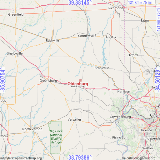
Oldenburg GPS coordinates[2]
39° 20' 23.172" North, 85° 12' 15.876" West
| Map corner | latitude | longitude |
|---|---|---|
| Upper-left | 39.88145°, | -85.90754° |
| Center: | 39.33977°, | -85.20441° |
| Lower-right: | 38.79386°, | -84.50129° |
| Map W x H: | 120.9×120.9 km | = 75.1×75.1mi |
| max Lat: | 71.29058° ⇑52% North |
| Oldenburg: | 39.33977° |
| min Lat: | ⇓48% South 19.06759° |
| min Long | Oldenburg | max Long |
| -171.73463° | -85.20441° | -66.98998° |
| W 55.4%⇐ | ⇒44.6% E |
Elevation
Elevation of Oldenburg is 273 m = 896 ft, and this is 21.8 m = 72 ft below average elevation for this country.
| Max E: |
3189 m = 10463 ft | 32.6% |
| Avg. | 294.8 m = 967 ft | |
| Oldenburg | 273 m = 896 ft | |
Min E: |
-60 m = -197 ft | 67.4% |
See also: United States elevation on elevation.city.
Geographical zone
Oldenburg is located in North temperate zone (between Tropic of Cancer and the Arctic Circle). Distance of this Northern Tropic circle is 1768.3 km =1098.8 mi to South.| Distance of | km | miles | from Oldenburg |
|---|---|---|---|
| North Pole | 5632.9 | 3500.1 | to North |
| Arctic Circle | 3027 | 1880.9 | to North |
| Tropic Cancer | 1768.3 | 1098.8 | to South |
| Equator | 4374.2 | 2718 | to South |


Nearby cities:
15 places around Oldenburg: (largest is in red/bold)
• Batesville
4.7 km =2.9 mi,  199°
199°
• Bright
32.9 km =20.4 mi,  114°
114°
• Brookville
18.9 km =11.7 mi,  60°
60°
• Connersville
33.9 km =21.1 mi,  9°
9°
• Greensburg
24 km =14.9 mi,  269°
269°
• Harrison
34.2 km =21.3 mi,  104°
104°
• Laurel
18 km =11.2 mi,  4°
4°
• Milan
25.1 km =15.6 mi,  165°
165°
• Milroy
28.7 km =17.8 mi,  307°
307°
• Moores Hill
27.1 km =16.8 mi,  158°
158°
• Osgood
24.6 km =15.3 mi, 197°
• Rushville
36.5 km =22.7 mi,  325°
325°
• Saint Leon
21.9 km =13.6 mi, 104°
• Sunman
14.8 km =9.2 mi,  140°
140°
• Versailles
30.1 km =18.7 mi,  187°
187°
Sources, notices
• [Note1] Compared only with cities in United States existing in our database
• [Src1] Map data: © OpenStreetMap contributors (CC-BY-SA)
• [Src2] Other city data from geonames.org with taken over terms of usage.
• [Src3] Geographical zone / Annual Mean Temperature by Robert A. Rohde @ Wikipedia
